Reply With Quote
Wow, I absolutely love this! The mountain ranges feel so organic.


Hello everyone!
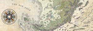
This is my map of the Garafold, a large nation composed of 14 territories on its own contient. It is located on the equator, 90° east (on this world it's called oriental) of the planetary axis. As this planet is tidally locked, the norther (lux) part is in eternal sunshine while the south (nox) is in the shade.
The Garafold has a fairly rich backstory with two competing powers who tried to colonize it, but who both lost in the end when their colonies joined forces and turned against them.
I have a bit more lore on this place and I'd be happy to explain if there's interest.
Please let me know what you think


Wow, I absolutely love this! The mountain ranges feel so organic.
Thanks, I made them in Wilbur, though I'm still struggling with the scale a bit. If anyone has a more comprehensive Wilbur guide than the one that's on their website I'd be very grateful.
It very well done.
I doupt there are better guides than on the official site. Have you read "having fun with Wilbur with friends" ?
Anyway, you can also ask Waldronate, he is always eager to help.
My Deviantart: https://vincent--l.deviantart.com/
This is awesome! Really well done, Id love to know youre process and how you got the contour lines to look so good from Wilbur, did you draw them out by hand after generating them? And what guide were you using because this looks great.
I have a basic tutorial from an earlier map of mine:
https://drive.google.com/file/d/1p6Y...ew?usp=sharing
This time I converted the raster image of the contours into vectors in inkscape. It was very difficult to get it to work.
For Wilbur I just used the tutorials on their website at first and adjusted the method until I got something that looked right.
Let me know if you want to know anything else!
Excellent map.
"We are the music makers, and we are the dreamers of dreams"
You've developed a very effective atlas style!
Thanks for sharing your method.
Thank you everyone for your kind comments! I'd love to participate more in the community and become a part of it. How do people usually stay in touch here and where is the meeting place to talk about your current projects?
This is a fantastic piece and thanks a lot for sharing your method with us
 Posting Permissions