Results 1 to 3 of 3

Thread: My first map ever

  1. #1

    Help My first map ever

    Hey folks,

    my name's Shyvver and I'm new here on this board (guild).
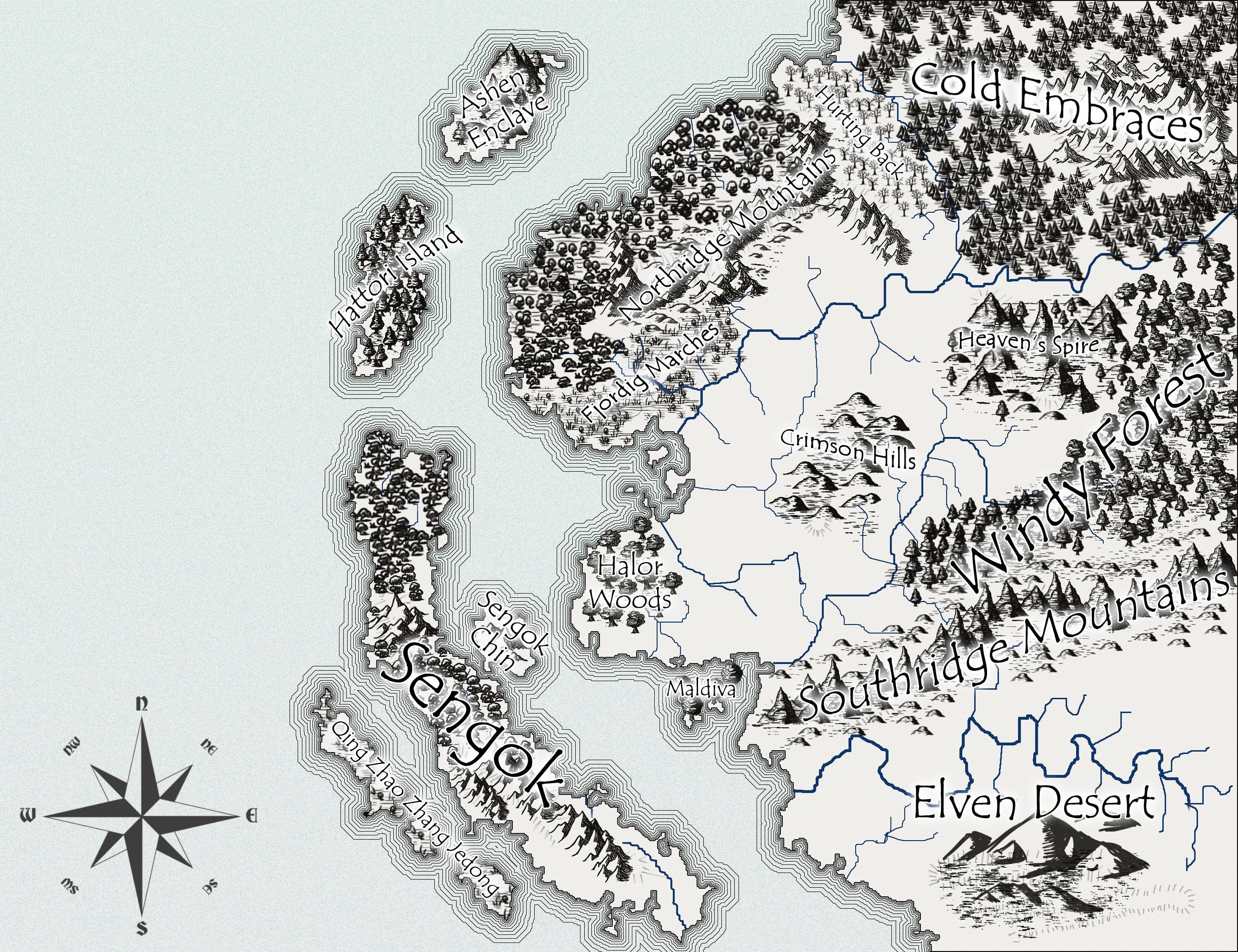
    I want to start a DnD-group with a couple of friends and decided to try and create my own region map of the world we're going to play in. I read a bunch of tutorials and tried to do a few things from some of them, leaving me with this map:


    The terraine is pretty much only brushes, so that's why they are different sizes, and some even have a different source than others. Also some are overlapping. I know thats not optimal. Do you guys have any ideas how to make this map more "map-esque"-looking? I'm using Photohop for this btw.

  2. #2
    Guild Adept Facebook Connected Llannagh's Avatar
    Join Date
    Aug 2013
    Location
    Germany
    Posts
    318

    Default

    Welcome to the guild, Shyvver!

    I think your map does look pretty map-py already!

    I'm assuming you're working with a mouse? If you're REALLY serious about digital mapmaking and have a little money to spare, you'll want to invest in a tablet eventually. That gives you much more control over your linework. If you don't want to get one, I suggest drawing your map on paper in black and white and then scan it or maybe take a picture and color it in digitally/label it.

    I guess the biggest problem with your map would be the rectangular, pixely feel to it. Try a higher resolution maybe. Also, your rivers are not all in the right place, maybe have a look here. In short, rivers don't split up or go from coast to coast.
    The labels cover up parts of the coastline in some places, so maybe make them smaller.

    Apart from that you're off to a good start. Your choice of color is easy on the eye and it's pretty informative.

  3. #3
    Banned User
    Join Date
    Jul 2014
    Location
    Traverse City, Michigan, USA
    Posts
    2,547

    Default

    Hello Shyvver, welcome to the Guild!!

    And excellent job for your first map, congrats and have some rep!

    A few comments ... your rivers are much too jagged, they need to be smooth curves and they need to join in the downstream direction. See here for some explanation:

    http://www.cartographersguild.com/sh...ad.php?t=30156
    http://www.cartographersguild.com/showthread.php?t=3822

    There is also some info in the first of those about mountain and tree vertical sizes.

    ... your coastal wave lines are too many and too close together, and too jagged. See here for a tutorial on making them a little smoother:

    http://www.cartographersguild.com/sh...ad.php?t=30388

    I like your font, but I think a little bit bolder and a little more outer glow to help distinguish from the background would help.

    So all of that said, I think you have done a really great job and I'll certainly look forward to seeing more of your work!!

Posting Permissions

  • You may not post new threads
  • You may not post replies
  • You may not post attachments
  • You may not edit your posts
  •