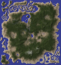
ok, now I hate you. Been trying the last 3 days to get something somewhat ok. I'm still far off but getting there slowly. that's a nice map. I would have tweeks though on the moutain ranges lolol currently trying to get it. I hope some day.


ok, now I hate you. Been trying the last 3 days to get something somewhat ok. I'm still far off but getting there slowly. that's a nice map. I would have tweeks though on the moutain ranges lolol currently trying to get it. I hope some day.
The critical part about doing Wilbur things is to not spend too much time and effort doing the masks. You're not going to have much control over anything but the grossest elements anyhow. I recommend playing around with lower-resolution maps for a while because they go very much faster than larger ones (the incise flow and river finding operations, for example, are O(n*n*n) operations). The terrain-processing parts break down to:
making the masks (use final resolution, coastline of reasonable detail, broad strokes for low mountains and high mountains)
setting initial altitudes for the masks (I like to use 100ish for coast mask, 1000 for low mtn mask, 2500 for high mountains)
goto process
loop:
resample larger
load land mask
invert to select sea
set to low value (-1 to -10) to keep sea clean at new resolution
process:
load land mask to keep noise out of oceans
add uniform noise to get more detail
fill basins to ensure river connectivity
incise flow to force rivers into terrain
precipiton erosion to clean up sharp edges
if not done, goto loop
morphological erode to clean up the little spikes left over from uniform noise
fill basins to ensure river masks will flow correctly
export a bunch of grayscale maps for final assembly in Photoshop (lighting, color, bump, rivers, etc.)
assemble images, usually with multiply for grayscale
add pretty things (this is the part that I always get wrong and that takes the longest).
I've been piddling about with Wilbur and its ancestors for a good 25 years. I would expect you to get good results much sooner than that!
Some year I'll get the system rigged to where I can basically just record or enter the above loop directly.
unfortunately there is NO substitute for PRACTICE
Half of it is "a feel" for it and that takes practice
--- 90 seconds to Midnight ---
--------
--- Penguin power!!! ---
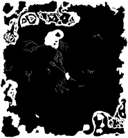
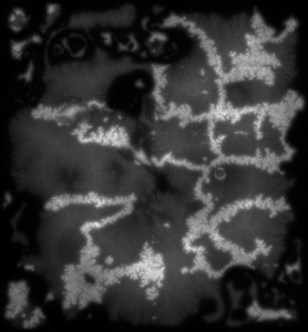
Well.... still got a ways to go it seems. I get something not to bad in wilbur (I think), then I gte this in GIMP. How you you save in wilbur to not loss the image. When I save as texture, I can't reload it in wilbur. I just shows a **** load of specs.

Use File>>Save As with a file type of MDR. It will save a binary image that stores the full resolution of the data that Wilbur uses internally as well as some information about the map edges.
That's a pretty good start. It looks like you did an incise flow without following it up with a precipiton step. The incise flow leaves those deep channels in the terrain that the precipiton step will tend to smooth out. A Morphological Erode step will reduce the speckling all over the map.
You can add 100 or so to the surface and then try a noise/basin fill/incise flow combo to add river channel detail on the flat area. Using Incise Flow with amount=2,exponent=0.4,blend=0.3, and pre blur=1 should help things out.
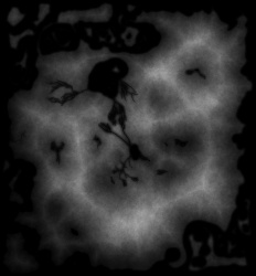
just some fun , from the old taped together image above in post #19
a bit too much with the "distance transform " the ridges are rather pronounced
Last edited by johnvanvliet; 02-13-2016 at 10:20 PM.
--- 90 seconds to Midnight ---
--------
--- Penguin power!!! ---
http://www.fracterra.com/test2a.jpg is the full-resolution version of the thing that I did before. I include it here because it's an interesting contrast to johnvanvliet's version above (especially in the details), not because I'm trying to do any sort of one-upmanship. johnvanvliet's map looks to be highlighting one of the serious limitations of Wilbur's precipiton toy: it tends to run things along the 8 cardinal directions. I include the noise and incise flow steps specifically to break that tendency.
On your version, there are many straight lines radiating out from the spines of the mountains. That's caused by too little noise that would force the erosion to one side or another and instead lets it flow straight downhill.
One of these years I'd like to sponsor a challenge similar to the "fill in the blob" challenges that come up regularly, but with a constraint that Wilbur be used in the process. Possibly even include a mountain mask, a few rivers, and some other minor elements that would need to appear in the final result.
Anyhow, I'm not trying to be difficult, I'm just trying to offer advice on using a rather quirky tool.
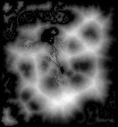
well a bit more details on the moutains but still sucks. rofl.. I'm basically trying to get the mountains high with white peaks maybe a slight brown around them and nice bumps on the flat areas and rivers going around. Well like the example I showed on page 1.seems I missed alol of that. hahahaha

I think the gradient I'm using is not good for what I want either BUT, it should give something much better anyhow. I can't seem to have rivers. the precipitation seems to erase all traces except the mountains of incise. and the mountains are to much eroded. they come down to being more hills and a few mountains then mountains. I need to enlarge the area of the mountains I think to get more of them into the rest without being to high. well like mentioned, not enough like the demo I saw. I'.m following the instrcutions but the bumps and gradients kill me. and the lack of rivers lol
for lowland area i use a "distance transform "
they say a pic is worth a 1000 words
-- example from a mask of the water and rivers - with a bit of noise added
-- the mask
-- the distance transform
-- the grater the distance form the edge of the mask the brighter
then after a few erode cycles i move the gama point to "0.4" and blend it with the mountians
then the mix
i use the gimp plugin G'Mic
filters / G'Mic
then under the "contours " section is "Distance transform"
set "value " to 255
set "normalization" = to normalize
--- 90 seconds to Midnight ---
--------
--- Penguin power!!! ---
 Posting Permissions

 Reply With Quote