Reply With Quote
As I have already said, it is really a very nice map with a very particular style that you have kept in every aspect ... congratulations !

Ok so I did follow both advices : more clouds but lowered the opacity. It seems like a good compromise.
Here is the final version and this is my 2000th message!
### Latest WIP ###
And here's the high quality version, almost as good as the psd file.
I also have flags. It's a made up character that does not exist, using 2 radicals.
I apparently decided it meant Kun, the name of the ruling dynasty.

Last edited by Azélor; 08-18-2017 at 12:59 AM.


As I have already said, it is really a very nice map with a very particular style that you have kept in every aspect ... congratulations !
I think that looked fantastic in the main version and then opened up one of the high quality ones and it looks way better. It's amazing what a little compression will do to the image. I like the cloud idea a lot, especially the easter eggs.
Fantastic map Azelor ! It took some time but the result is way up to the expectations !
Thanks everyone!
I made some more thematic maps for fun. Well actually, I was interested in getting more accurate information on demographics.
The final numbers give me an area of 8 445 777 sq km and with 118 725 829,03 people (to be very exact). With an average density of 14 per sq km.
The country comprise 24 provinces, 1 unorganized territory,1 protectorate that has a lot of autonomy, and possibly occupied territories in the east (actually it's in the lower center of the map)In the east, Tainotim mentioned that a civil war occurred several years prior to the map (not specified how long exactly). His map doesn't contain details on the north west part of the map.
I had the idea that, during the civil war, the government fled to the north west when the end was near. Under the protection of my country, they managed to keep their ground in that region, planning to comeback for a revenge. Although an independent state (de jure), the Empire's influence (me) is very strong and doesn't plan a war anytime soon.
The area controlled is 350 000 sq km and has close to 10 million people.
The exact wording is not occupied territories but puppet state, I think.
Each provinces are divided into several counties depending on geography, population and randomness.It is generally the smallest administrative unit but some cities have their local government.There are 354 in total. Each has at least one population center where the government hold their offices.The size and number of people in each county is not very consistent. The government does not modify them very often.I compiled some data:The smallest county is 364 sq km. The largest is 349 900 sq km, larger than Italy, and also larger than half of the provinces taken individually. Yet, only 100 000 people live there.The average is 23 000 sq km.The most populous has 738 000 people, the least populous has 64 000.
The largest province is 1,2 million sq km, 4 times the size of Italy but is mostly uninhabited.
Now the maps:
Updated province map:
Names can be found here: https://www.cartographersguild.com/a...3&d=1503031363

Continuation of the previous post. I got an error that it was too long.
Maybe I had too many pictures? No the problem came when importing the excel chart it had over 200 000 characters.
Same map with an equal area projection, Albert conic. Also showing the possibly occupied territories mentioned earlier.
Attachment 101220
This is a chart made in Excel showing the proportion of land and population for each province. If the red bar is higher, it means that the population density is high.
County map, each province has a different color, it's mostly random.
Population density by county. Pure black is 0, pure white is 100 people per sq km (or more).
To get a better idea of population distribution, I also did this map:
It shows the total population for each county using a greyscale of 1 level of brightness for each 10 000 people.
So at 100, pure white, the population would be 1 000 000.
Lastly, I did try to map the different language spoken in the Empire. Not an easy task since there doesn't seems to be a clear definition of what a language is, compared to a local dialect. When does the shift happen?
It is far from complete.
Languages that have similar colors are either part of the same language family, or are regional dialects.
Flat areas tend to have more homogeneous languages while isolated and hilly areas are more diverse.
My thoughts is that the country could be home to several hundred languages. It's a conservative estimate, since Nigeria has apparently over 500 different languages.
Only the dominant languages of any area is shown and small pockets do not appear either. Thus, many languages are going to be left aside.
For anyone who already tried this, how does it look?

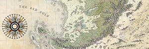
I'm reposting the map properly with a cropped version for the world map.
Also, the thumbnails was showing the last image of my "lastest wip", which was a flag.
### Latest WIP ###

I don't know which of your map's to praise first! Your city map is crazy level of detail, and so is this. Great job on both of them.
I really love this map! The ancient Chinese inspired style feels spot on. I'm trying to learn a style similar to this for my Chinese and wuxia inspired maps so this is a great inspiration!
I am posting the following here instead of a separate thread because it is not a proper map (not yet).
WARNING before you read further, this is mostly for world building purposes.
It started as an idea I had a while back.
This is a small province and I was wondering what it would look like if I tried to show every single plot of land on the map.
It turns out that it's not that small, it is larger than Belgium.
Info on the province:
- Name: Sanhejie: Where the three rivers meet
- Area: 31 052,70 km2 (slightly larger than Belgium)
- Population: 3 069 593
- Urban: 552 527 (18%)
- Rural: 2 517 066 (72%)
- Population density: 98.9 per km2
- Average person per household: 5.5
Land usage (estimation)
- Farming: 81,5 % (25 307 km2)
- Woodland: 7%
- Marginal woodland 2%
- Water: 3%
- Wetland: 2%
- Infrastructure 2% (roads, irrigation, dikes, etc)
- Unused land 2%
But I'm still missing the sense of scale.
So, my question is, how many farms or villages does the province has?
Finding the rural/urban population.
Based on Renaissance Italy, the urban population hovered between 16-18% at maximum. So I chose to use 18%. This gives me a rural population of 2 517 066.
Villages:To begin, the structure of the society is based around the village and rice farming.
Rice is a very productive crop but also very labour intensive.
Therefore, people regroup and work the same field(s) instead of having each household working a small plot of land. This makes things easier as each village can be shown having only one large paddy field or several depending on what is best looking. Small hamlet are virtually nonexistent and the smallest villages usually have around 100-200 people.
To find out how many villages, I used the same principle regarding the size of cities. Most cities have an optimal size around 1km2 (according to Medieval demographic made easy). Looking at real maps, this seems to make sense for villages as well.Divide the agricultural area by the average area of each village:
25 307 /1 = 25 307That was easy, but it’s only a reference since the placement of villages is not optimal, there will be a lot of wasted space in between.Large villages: population around 500
They serve as local trade hubs with some craftsmen living there. They cover a larger area but aren’t that bigger than the smaller villages.
Based mostly on observation of real world maps, the distance between these is 5 km. Which mean that people are never more than 2,5 km away from the closest large village. (now I realize the name sounds silly)
2.5km takes 30 minutes. Someone could walk that on a regular basis if required.
25 307 / 25 = 1000 (closer to 925 to be more accurate)
Towns : Population of a few thousands (3000 on average)Towns are much larger and they have a specialized workforce. Their markets are much bigger and might have access to faraway trade if they are located close to an important road. Many towns have some government buildings and temples.
Town are further away with 20 km between them. People are never further than 10 km from the nearest town. That is a 2h hours walkThey cover an area of 400 km225 307 /400 = 63
I think the actual number is 72. This might be because the land continues beyond the province borders and the distribution in uneven.
Cities : Population starting generally around 5000 or 6000Cities are large urban centre with a much diversified workforce and markets. They have specialized worker that are rare in smaller settlements. Cities are usually the centre of the county, which is a local government administration.
The placement of cities is even more dependent on the surrounding. It is skewed depending on different factors like connection to the trade network, history and other things.
I set the number of cities at 11,5. (the .5 is because one city is halfway into the other province)
Based on observation (which may not be very accurate), each city cover an area of 2500 km2.This was the number of cities already on the map and by looking at Renaissance Italy, I think it’s good.
https://www.ehs.org.uk/dotAsset/491c...8b23ef47b7.pdfThe largest cities are in order (subject to change):
150 000 / 30 000 / 25 000 / 20 000 / 15 000 / 14 000 / 12 000 / 10 000 / 9000 / 7000 / 6000
I also count towns as part of the urban population, for almost half of the total.
Placing the settlements on the map starting with the cities
Towns:
Large villages:
Villages:
Urban area scaled properly (I think)
It looks like a magic lamp, don't you think ? Or a shoe...
Forest:

In conclusion, I wanted to work on this for the ongoing contest but I will have to find something less insane.
I will probably map this province later but for the moment I will do exactly as planned but will focus on a single county.
https://www.cartographersguild.com/s...870#post408870

Last edited by Azélor; 11-11-2019 at 12:53 AM.
My Deviantart: https://vincent--l.deviantart.com/
 Posting Permissions