Reply With Quote
It's great to see this map finished after seeing the work in process thread, it's come out really great!


So! For the past 3 weeks I've been working on a private map to try my hand at a different style than what I usually do. The map isn't rooted in any already existing alternate universe, but for the sake of completeness I made one up anyway - I feel a random map without any roots always kinda feels "thin". If you're interested in backstories and such, feel free to read the explanatory notes below. If not, just enjoy the map!
So I decided this map would be part of the Breistyn universe (I just invented it, no need to look it up), and is in itself one of the major plot devices. It was commissioned by the nation of Krastvin Shalts to display its geopolitical prowess. The nation is not the largest in area, but it dominates several major locations on the map. (i) The isthmus in the northern continent is controlled by its western capital. (ii) It has conquered most of the islands in the Straits between the two continents. And (iii) its eastern capital is situated on the only major island in the Fossbiddrian Gulf, which lends Krastvin Shalts a crushing grip on most trade routes in the area. Krastvin's undeniable power comes from its three fleets, ranging far and wide on the Fosbiddrian Gulf, the Krastvinian Sea and the Sartian Straits.
Krastvin's major competitor for world domination is Farghast Brin, the largest country on the southern continent, and one vastly populated. Climate is ideal for agriculture in most of the Farghast Dominion, its immense river network allows for rapid transport and communication with all of the surrounding countries. Krastvin dominates the seas, but Farghast reigns supreme on land, with its massive army mostly consisting of heavily armored knights and mounted archers. It has gradually expanded its own geopolitical sphere of influence by applying terrible military pressure on its neighbouring countries, which have by now become little more than satellite states.
A conflict between the two super powers has been evaded up til now, but it's clear that a confrontation is ultimately unavoidable. Krastvin Shalts has secured its grip on the northern continent and will inevitably turn its attention south, to the shores of Finstarn and beyond. Farghast Brin is actively trying to work up the economy of its vazal states and will not accept Krastvin's iron grip on their economy for much longer. A clash is bound to happen. The only question is now "when", so both have started preparing the inevitable in earnest.
-----------------------------
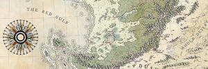
However. There is one problem that both super powers will have to tackle before they can have any hope on winning this conflict: it is almost impossible to accurately map the Breistyn world. Many attempts have been made in the past, but all seem to strand on one strange but very real property in the Breistyn universe: a phenomenon scholars have started to call the Spatiodynamic Field. It is a field that expands and contracts space in such a way that travel times are almost impossible to estimate accurately. It's not like winds are slowing you down, the actual distance measured between any two points - plotted however accurately - changes over time. And sometimes by a lot.
The compass in the lower left corner indicates the strength of this weird field on its inner ring. For more information about the compass, be sure to check out the dedicated deviation. It's weird and crazy and fun in its own silly way! For this map, it suffices to say that the compass helps in calculating the distortions caused by the field, and that way estimating the "actual" distances assuming a uniform, neutral field strength. Thousands and thousands of these measurements have been logged by Krastvin's merchant and navy fleets over the past few years, in utter secrecy, and their reports were then used to create this map. Now, with the map and your own Mihorian Compass, you should be able to estimate your actual travel time between two points on the map quite accurately. At least in theory. Because the compass hasn't been released to the public. It and this map are secrets only known to a very few in the highest places.
In order to help a navigator work out the distance distortion, the map also displays a graph in its bottom right corner. It's actually just a variation on a classic scale, worked out as a function of the field strength.
-----------------------------
Ooh yeah, almost forgot! The script used on this map is called "Shirn Brádulë". I actually developed it for my upcoming fantasy cycle (which has nothing to do with this map), but I thought I'd give it a test run here. I developed a font for it as well, so feel free to give me a yell if you're intested!
Caenwyr Cartography
Check out my portfolio!
It's great to see this map finished after seeing the work in process thread, it's come out really great!
Beautiful
I like the font. You've made me want to develop my own. How do you go about doing that?
Free parchments | Free seamless textures | Battle tiles / floor patterns | Room 1024 - textures for CC3 | GUILD CITY INDEX
No one is ever a failure until they give up trying
Thanks Mouse! There's several software packages that let you create your own font, some of them (notably FontForge) even free of charge. I dabbled a bit with the freeware versions, but ultimately went with FontCreator instead, which is a really versatile and complete package, albeit not particularly cheap.Originally Posted by Mouse

Caenwyr Cartography
Check out my portfolio!
The optical metrics I see being displayed on FontCreator's page make that the bees knees, but I think I need to have been working a bit longer before I can get seriously into making my own fonts.
Thank you very much for the information
Free parchments | Free seamless textures | Battle tiles / floor patterns | Room 1024 - textures for CC3 | GUILD CITY INDEX
No one is ever a failure until they give up trying
The map is a blast but the idea for that compass ... oh my ! That's some serious science fantasy idea !


Fantastic map and marvelous choice of colors !
Well, if I go for something (which admittedly doesn't happen too often), I go all the way
That's what I love about this forum: a bunch of people with the same passion being actually kind to each other (which is a rarity in online forums!) and helping one another out. Thanks a bunch for your kind words Mouse, and I'll be happy to provide more info on that font creating thingy whenever you like.
Thanks JO! As a matter of fact, there was quite a bit of (friendly!) discussion regarding the colours on the WIP thread, and I'm happy to hear you like what it ended up like.
Caenwyr Cartography
Check out my portfolio!
Wonderful! The font and the compass are pure genius
Francesca Baerald - http://www.francescabaerald.com/maps/
 Posting Permissions