Results 1 to 3 of 3

Thread: A fantasy world, how to shape it to a fantasy history?

  1. #1

    Map A fantasy world, how to shape it to a fantasy history?

    Hi, nice to meet you all. First time poster, I hope we'll all get along.

    I'm currently making a fantasy world for a D&D-esk setting, and made a first world sketch. I like it thus far, at least as far as I can ever satisfy my own inner critic, but I do have some questions that I would like the imput of others of. I hope the details are clear enough to see. I know the writing isn't, unfortunately I don't have a way to scan the size of paper I used with a high enough resulotion for that. Perhaps the colour stuff is difficult too considering the quality of the image and me using markers that are literally over a decade old. But before I digitally trace the drawing and fix those issues, I would like to get some feedback on some things.


    Legend:
    -Pink are the alliance lands (with free humans.)
    -Green stripes are magical/ancient/lushious wilds with the fey
    -Green borders are the domains that the fey protect (when they don't own the land)
    -Vague pink is Kil'Neah (fire giant) territory, a.k.a. the lands of the 99% certain antagonist of the campaign.
    -Yellow are mountain ranges (Not every mountainous area is marked yellow, just the really mountainous ones.)
    -Red stripes are polar/tundra lands.
    -Blue is the border between the Earth and Sea realm.


    Questions:
    1) General opinion. I myself think the continent looks just a bit too ball-y despite my attempts to make it look good, but I'm wary of making multiple continents.

    2) The land to sea borders. This is my main question for imput (and hopefully sparking a discussion). In my campaign in the early days before mortals, the earth and the sea gods were in a war to decide which phase should be the one to be the planet's surface. As such, I made the coasts a bit more jagged and with mountains as a literal wall against the sea here and there. So, my question is: How do I best shape a world where the coasts are shaped by an ancient war rather than natural events? How to portray conquest-defined borders similar to European ones after a few thousand years of peace?

    3) Alternative city-shaping. The draconic lands (south-west and north-east) are devoid of big cities. I want to give them a different way to show the centre points of their infrastructure, but came up with zero good ideas to show it. Dragons would put more importance in their lairs than their kobolt-cities, and even their largest cities wouldn't actually be important ones. But I don't want to add a thousand little mountains or towns to the map, nor do I want to keep it entirely empty. Any ideas?

    4) I have a few cities in the sea, but I don't want to make the map even more confusing by adding the borders of underwater kingdoms and their cities too. Should I just leave them out (and hope the party never develops a significant interest in the sea bottom other than a few important areas and sunken cities) or define these after all? Perhaps there's someone with a really smart idea?
    Last edited by Mammon; 04-20-2018 at 07:27 AM.

  2. #2
    Guild Grand Master Azélor's Avatar
    Join Date
    Jul 2008
    Location
    Québec
    Posts
    3,363

    Default

    1) General opinion. I myself think the continent looks just a bit too ball-y despite my attempts to make it look good, but I'm wary of making multiple continents.
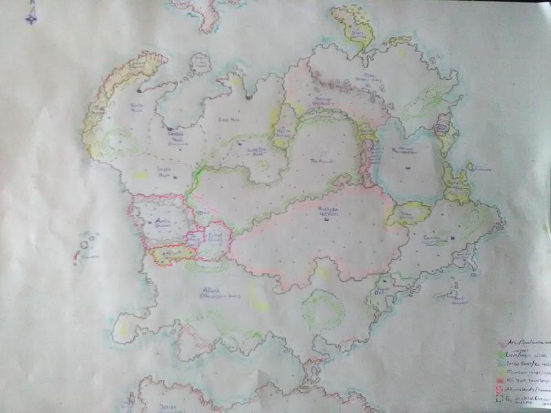
    There are famous worlds more bally than your like:
    https://www.google.com/search?client....0.T0drfTZNdv0
    https://www.google.com/search?q=cona...w=1920&bih=946

    2) The land to sea borders. This is my main question for imput (and hopefully sparking a discussion). In my campaign in the early days before mortals, the earth and the sea gods were in a war to decide which phase should be the one to be the planet's surface. As such, I made the coasts a bit more jagged and with mountains as a literal wall against the sea here and there. So, my question is: How do I best shape a world where the coasts are shaped by an ancient war rather than natural events? How to portray conquest-defined borders similar to European ones after a few thousand years of peace?
    Normally, political borders tend to follow natural borders (rivers, mountains...). But in this case, the borders would be defined by war and politics alone. With politics/treaty, you have maps with straight lines : US states and Canadian provinces.
    Or lines than do not always follow the geography: Korea, Cyprus. They are based on what each side controlled when they decided to stop fighting.
    So there is no clear answer to that question. It could depend on how they are fighting.
    With trench warfare for example, it would make sense to have jagged coasts but islands (big and small) would be almost inexistant.

    [QUOTE][3) Alternative city-shaping. The draconic lands (south-west and north-east) are devoid of big cities. I want to give them a different way to show the centre points of their infrastructure, but came up with zero good ideas to show it. Dragons would put more importance in their lairs than their kobolt-cities, and even their largest cities wouldn't actually be important ones. But I don't want to add a thousand little mountains or towns to the map, nor do I want to keep it entirely empty. Any ideas?/QUOTE]

    If dragons don't live in cities but still have some on their territory, that is a start. Maybe other races are populating the area?
    Other than that, what kind of infrastructure do they have? They could have build thing although dragons usually don't, but that is not something you can't change.
    They could have statues, towers, nests.
    maybe someone lived on this land before them and they left ruins behind.
    Dragon can make magic? so a magic structure.

    4) I have a few cities in the sea, but I don't want to make the map even more confusing by adding the borders of underwater kingdoms and their cities too. Should I just leave them out (and hope the party never develops a significant interest in the sea bottom other than a few important areas and sunken cities) or define these after all? Perhaps there's someone with a really smart idea?
    With the current image resolution, we can't see well enough to read the labels or distinguish the different areas.

  3. #3

    Default

    Thanks for your reply and imput, very helpful!

    Quote Originally Posted by Azélor View Post
    Normally, political borders tend to follow natural borders (rivers, mountains...). But in this case, the borders would be defined by war and politics alone. With politics/treaty, you have maps with straight lines : US states and Canadian provinces.
    Or lines than do not always follow the geography: Korea, Cyprus. They are based on what each side controlled when they decided to stop fighting.
    So there is no clear answer to that question. It could depend on how they are fighting.
    With trench warfare for example, it would make sense to have jagged coasts but islands (big and small) would be almost inexistant.
    Between Canada and Korea, definately the second one. Even if there were straight line coasts, unlikely considering the war ended with one god defeating the other and just stopping the war+coast building right then and there, those would've corroded to wobbly versions after a few thousand years. Trench warfare is tough, I do like the idea but don't want to give up all the islands... Thanks for the ideas!

    If dragons don't live in cities but still have some on their territory, that is a start. Maybe other races are populating the area?
    Other than that, what kind of infrastructure do they have? They could have build thing although dragons usually don't, but that is not something you can't change.
    They could have statues, towers, nests.
    maybe someone lived on this land before them and they left ruins behind.
    There are plenty of other races, I just don't see them and their cities having true relevance in terms of trade and such. Or having roads. I mean, it's not impossible, but I still have to figure out what kind and level of infrastructure races that aren't trade-oriented and ruled over by a dragon who can fly and thus sees little need for it would have.

    With the current image resolution, we can't see well enough to read the labels or distinguish the different areas.
    Sorry, I'll hopefully replace the image with a digitally enhanced one soon enough. The seas are everything around the ball-shaped continent except those thingies to the absolute south and north, and that ball-like thingy inside the ball-like continent in between the four yellow spots.

Tags for this Thread

Posting Permissions

  • You may not post new threads
  • You may not post replies
  • You may not post attachments
  • You may not edit your posts
  •