Reply With Quote

This is amazing! I looks just like a satellite picture!

Hey everyone
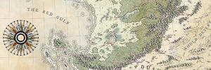
Here's a map i did of the zion national park. For this one and thanks to Blindblake advise, i tried to use texture shading techniques to depict topography. The map is a combination of qgis, photoshop and a soft that helps to apply texture shading effect on elevation data.

My Fantasy maps : http://www.cartographersguild.com/al...p?albumid=4205
Website: http://francoisgueydon.jimdo.com/fantasy/
This is amazing! I looks just like a satellite picture!
Pretty impressive
I think you may just have found the solution to drawing top down forests of enormous size!
Free parchments | Free seamless textures | Battle tiles / floor patterns | Room 1024 - textures for CC3 | GUILD CITY INDEX
No one is ever a failure until they give up trying
Wow, this is impressive! The colors are wonderful, and I love those trees. Thanks for sharing.
Cheers,
-Arsheesh
Really terrific!
I'm always fascinated by your satellite-style maps. And the Zion National Park is a so dreamful choice...
Thanks a lot everyone for the kind comments and the rep, greatly appreciated
My Fantasy maps : http://www.cartographersguild.com/al...p?albumid=4205
Website: http://francoisgueydon.jimdo.com/fantasy/
This is amazing ! As Dan said, this looks like a satellite picture !
Very nice map! I love the general feeling and the sense of the topography/colors.
I have a few nitpicks : some labels are a bit hard to read, imo... And I'm wondering how it would look with multiply effect or some transparency for the roads.
Although satellite style maps are not my favourite kind, this is very well done! You're the GIS master!
Will rep if I can.
"We are the music makers, and we are the dreamers of dreams"
Thanks for the feedback, advices and rep!
About labels i originaly worked with twice the resolution for the map but i had to reduce the size of the final file, so they are not as legible as i intend to
My Fantasy maps : http://www.cartographersguild.com/al...p?albumid=4205
Website: http://francoisgueydon.jimdo.com/fantasy/
 Posting Permissions