Reply With Quote

Look out! It's a crazy person
This is an interesting series of maps, Caenwyr. If I may say, I think I like the mouse-drawn map the most. Good luck condensing this into A5...
Wingshaw


Oh hey all!
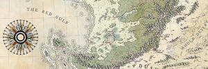
Those of you that have followed me a bit w ill probably be struck by horrible waves of déjà-vu when they see this map, and for good reason: I have indeed tried my hand at them before. As a matter of fact, I've been writing a novel for over 18 years now (more than half of my life - yes I'm crazy!) and I just now started doing the rounds past the publishers. I actually found one who's interested! Which means that I'll need a version of my map that's printable in a book, so both colouring and resolution need to be adapted.
Over the years I've done several versions of my main map:
- a hand-drawn version I did at the very beginning:
- a first digitization using Arsheesh's awesome Eriond tutotial
- a hand-drawn reworking (using a mouse, for Pete's sake!)
- a re-digitization, now using my own weird, incoherent technique
I also did several city maps for locations on this larger map, and even one building map (which I had a ton of fun with). All interspersed with different maps for private projects or commissions.
And now I'm back to this map again! Only this time I'm gonna try and have it fit on A5 format, and do it all in B&W. Gods have mercy on me...
Caenwyr Cartography
Check out my portfolio!
Look out! It's a crazy person
This is an interesting series of maps, Caenwyr. If I may say, I think I like the mouse-drawn map the most. Good luck condensing this into A5...
Wingshaw
Formerly TheHoarseWhisperer
Thanks Wingshaw! I like the hand-drawn style best as well, although I have luckily evolved a bit since that early iteration. I intend to use it for the A5 version too, although with some tweaks to keep everything legible.Originally Posted by Wingshaw

----------------------------------------------------------
My progress up to this point:
So I had my large-scale map (the last one from the first post), and a more zoomed-in map of just the central mountain ridge. Resizing these to A5 and overlaying them one on top of the other gives you this:
Attachment 108311
I then used this as a basis for a new coastline, and new sketchy mountain and hill ranges:
Attachment 108312
Which then got elaborated further into separate mountains and hills:
Attachment 108313
I then started inking the mountains in, but soon some vague dread started creeping up on me: would this actually be visible on that small size? So I printed it out on the right format, and this is what I get:

So basically no, these overly detailed mountains are so tiny they can't possibly be distinguished on that size. Especially not considering book prints generally don't have this high a print resolution. So... I guess I'll have to erase the mountains I have, and come up with much simpler ones. A style I've always wanted to do but always kept drifting away from, and now I'm gonna be forced to do it. You see, all works out!
Last edited by Caenwyr; 07-10-2018 at 06:02 AM.
Caenwyr Cartography
Check out my portfolio!
In France, we say "cent fois sur le métier remet ton ouvrage" which roughly means "go back at it you unhinged 8astard" and I can respect that. Seeing this one in your current style will be a treat for sure
To address your issue, you might need more crisp lines. It can be achieved by working at a lesser zoom. Sorry if I have no better advice.

I am very excited to see how this map unfolds and hopefully we'll see your book published. I'll give it a read, especially after watching the life birthed to this map. Cheers!
Very cool! I am looking forward to this... a lot. Your Dragon's Backbone map is still one of my favorite CG maps.
So yeah, i'll be sitting here and watching this thread with anticipation.
Maybe it's just me but from your progress update i can only see the last map attachment, all the others give just an attachment link that does not work if clicked on.
I'm trapped in Darkness,
Still I reach out for the Stars
Well thanks guys, glad you're as enthusiastic as I am!
Yeah, I noticed it too! The images were there when I checked my new post, but now they're gone. Weird! No idea where that came from, but I'll try to edit the post so all images appear.
Alright, update! As promised I threw away my mountains and started over. This is what I have now:
What do you think?
Caenwyr Cartography
Check out my portfolio!
This is turning out just lovely, Caenwyr! I'm glad you started over on the mountains, they all seemed to have the same zig-zag thing going on, and I love variance.I love your shade work too, it's turning out really clean so far, keep it up!
Thanks Adfor!
Alright, here's a first test with some labels. I'm starting to discover this map is gonna have to be waaaay more minimalist than I'm used to doing, but I guess that's fine: some practice for future print jobs

Caenwyr Cartography
Check out my portfolio!
I like it a lot, Caenwyr! Still the very iconic needle-pointy mountains i know from your works
The labels work well, i think, but i don't like the (country-borders?) lines...they just cover up too much of your lovely mountains. I'm not sure such borders are really necessary if there are country names and the mountains display such clear natural borders. But then that may just be me.
I'm trapped in Darkness,
Still I reach out for the Stars
 Posting Permissions