Reply With Quote
Hello,
Is there no quick tips to do that ?


Hello,
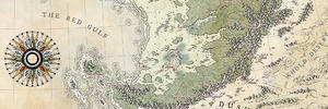
I want to know if there is a simply method (Photoshop CS6) to draw a scale marker all around a map, like on this picture :
In order to have equidistant black and white pattern all along width and height.
Thank for your help.
Hello,
Is there no quick tips to do that ?
I can point you towards this (a series of articles on procedural border construction) but for the rest, I do mine by in a long process.
There's a tutorial for Gimp kicking about somewhere, but I can't seem to find it. I copied some instructions from it a while back, and saved it in a text file for my own use, but I haven't noted who created it originally (Thought it was Rob A, but I searched his tutorials and I don't think it was him). I had a feeling the Gimp tutorial was an adaptation of a Photoshop one, but I might be getting mixed up.
Anyway, does Photoshop have a checkerboard pattern? If so, you can probably adapt the tutorial. I've copied the Gimp instructions below.
1- Decide on the width you want for the lines, and enlarge the canvas to that size.
i.e. for a 1200x800 map you might want a neatline 20 px wide, so make the canvas 1240x840, centering the layers.
2- decide on a the number of segments you want. Keep it close to the same proportion as the image size so they
stay square. Using an odd number will ensure the same colour in all four corners.
3 - create a new layer this size.
4 - filters->render->pattern->checkboard, and select a value of 1 (pixel) The checkerboard is in your fg/bg colour.
5 - scale the layer to the image size, with NO interpolation (this is the magic step that takes care of the nasty math!)
NB Remember to uncheck the link that maintains height vs width proportion when scaling. The resulting scaled layer
should look roughly squarish. If the results aren't square, something's gone wrong!
6 - use the move tool to place it over the whole image.
7 - create a selection bordering the area. Select->all, select->border 20 (the size we wanted)
So, to simplify... say your map is 3500x2500px and you want your segments to be roughly 250px long. That would give you 17 segments x 12 segments, but we'll round up 12 so that it's an odd number. Create a layer that's 17x13px in size and fill it with a checkerboard pattern. Scale this layer up to 3500x2500 without any scaling effects. Create a selection the size you want the border, invert it, then delete the middle part of the checkerboard pattern.
Hope that makes sense!
"We are the music makers, and we are the dreamers of dreams"
Thank for this useful topicOriginally Posted by ThomasR

@Chickpea : thank you for the tips. I'll try it soon


That's not a scale indicator. Chequed neatlines are best thought of as an extension of the graticule, the grid showing latitude and longitude, or some other coordinate system like UTM.
Drawing one correctly depends on the extent and projection of your map the same way that the graticule does. Drawing one wrong can say things about your map you may not want to say, and may even contradict other parts of the map.
The one in your example appears to be modelled on a modern road map street locator and suggests it's part of a larger road atlas because it isn't aligned to the map. This contradicts the style of the map though. There's also no graticule which is really odd for a map with a chequed neatline. There are sometimes situations that might justify it but it's very unusual.
Not all of the things you see on maps belong on all maps.
Thank you for the advice.
 Posting Permissions