Reply With Quote
Looking very good! And I'm always glad to see there are other crazy guys who do different thematic maps of the same world or region.


Originally Posted by Caenwyr

https://en.wikipedia.org/wiki/Caer
Yup, you can still see it in some place names today like Caernarfon
The map is looking really good!
Looking very good! And I'm always glad to see there are other crazy guys who do different thematic maps of the same world or region
The map is looking really good! I love the shape of the continents and this style of mountains - it fits this type of map very well.
And wow, that's a big decision to drop your story and starting a different one. I've also been working on a story for many years and it became completely overwhelming. Perhaps I should be as courageous as you and stop reworking the story again and again.
This is looking really good, I really like the shapes of the landmasses and just the level of detail.
View my map and asset packs on CartographyAssets or DrivethruRPG. Support my work on Patreon. Take a look at my work on my Website or Instagram.

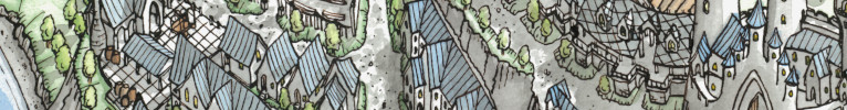
Hi people, I'm back with another update! And this one is actually substantial for a change. I'll let you guys guess what I added...
It's the terrain!
Sorry for spilling the beans, I just couldn't contain my enthusiasm. There's a few dozen hours in this update so I'm glad it worked out. I still need to do the terrain for the southern continent (Sakhuria) though, so stay tuned for that!
Caenwyr Cartography
Check out my portfolio!


That's really looking fantastic, Caenwyr. I love that terrain look; you can see it, but it doesn't distract from the main goal of the map, the states and boundaries.
Thanks Diamond! That's exactly the effect I was after. I want the terrain to be "slightly visible but not distracting" when zoomed out, but "very present and a positive addition to the map-viewing experience" when looking from close by. I hope this ticks both of those boxes!
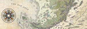
And here's the terrainwork for the southern continent! I spent over 12 hours on painstakingly drawing all of the isohypses, and then like 5 minutes pulling them through Wilbur.
I'm gonna spend a bit more time poring over it to find any remaining errors, and then this one's off to the Finished section!
Also, now that I have this, I can use it as a basis for maps of the same area but in a different year so I'll eventually have a complete historic overview of the region... or thematic maps like language/religion/culture/population density etc. Currently I'm itching to do a language map, but we'll see if I ever do any of them at all. I have several commissions lined up so those go first.
Caenwyr Cartography
Check out my portfolio!
Really awesome map, has turned out great and I love all the detail in it.
This is brutally good Pieter ! Atlas reliefs, fantasy coastlines and politic information representation worthy of a history book, you're outdoing yourself and that's no small feat !
Hi Caenwyr,
I love that most of the borders make sense, because they follow the topography of your continent like rivers or ridges. That makes it much more believable.
 Posting Permissions