Reply With Quote

All.. These… Trees.. So good! Where did you buy your patience? I’m in need of some.


Howdy, Cartographers.
I present to you my latest map.
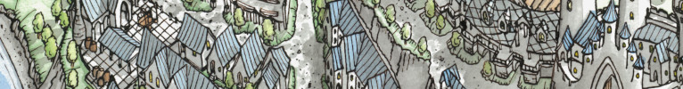
The map shows the surroundings of Grand Free City of Talabheim.
As usual, I drew this map for my rpg sessions.
I have prepared an English version in case anyone would like to use this map during their game.
I hope you enjoy it.
Original format: 150x140 cm
Technique: hand-drawn, acrylic inks, a touch of Photoshop.
HD scan on my Deviant Art: https://www.deviantart.com/mapyniepr...heim-900269491
Last edited by Impractical Cartographer; 12-15-2021 at 04:28 AM.
All.. These… Trees.. So good! Where did you buy your patience? I’m in need of some.

Lovely. I visited your Deviant Art site too. Love the Warhammer pieces, thanks for sharing.
Outstanding. The amount of trees is growing exponentially with every map. I would not be surprised to see a map of a forest only in the future
@Dimension Door I once saw him drawing those in real time... It was very soothing to watch
New Horizons
Fantasy maps and illustrations.
All my non-commisioned maps are FREE for personal use. Get them at my home page New Horizons
Get more of my maps by becoming my Patreon.
Support:
Patreon | Tip via PayPal.Me | Buy Me a Coffee
While drawing I listen to good audiobooks or podcasts and somehow it goesOriginally Posted by Dimension Door

Fortunately, the next larger map will show the tundra.
And there is already an English version of this map on Deviant Art.
https://www.deviantart.com/mapyniepr...heim-900281602
whoa nice! i love the trees
avatar by chuckdrawsthings. thanks chuck!
🛸Locus is creating Locus: The Magazine of the Science Fiction and Fantasy Field🛸
🌲link🌲tree🌲
This is looking really great. I was wondering how you digitise your maps, at 150x140 cm that's well above A0 size so I doubt you'd be able to find a scanner large enough. I know you can also digitise by taking photos but I've always found you get blurring at the edges for large images and it's so hard to get the framing really square.
View my map and asset packs on CartographyAssets or DrivethruRPG. Support my work on Patreon. Take a look at my work on my Website or Instagram.
You can easily find such scanners in good printing studios for architects and surveyors.There should be scanners that support widths up to 150cm / 60 inches.
Great work & map, once again.
Thanks for the tip, I did a quick search and I think I've found a place in my local area that offers this service. Up till now, I've avoided working at a size larger than A3 as I was unsure how I would be able to digitise the finished piece so that opens up some more options for the future.
View my map and asset packs on CartographyAssets or DrivethruRPG. Support my work on Patreon. Take a look at my work on my Website or Instagram.