Reply With Quote
Thats very cool. I like it and we could do with more non fictional / fantasy maps here. Never been to the Hebrides as its a bit out of reach but I bet its real nice in a rugged sort of way.

Thought I may as well post this since it's quiet around here...
I've recently been getting into QGIS. We had a mapping project at work a few months back. Google Maps wasn't cutting it and I had a feeling that QGIS might work (I was familiar with the software from hanging around here, but I'd never really used it). So after a crash course I figured out the work thing, but it left me interested in what I could do with QGIS and I've been dabbling off and on since then.
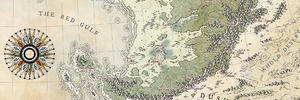
I put together this map over the last few days. It's not a fantasy map but it's done in a sorta fantasy style, so figured I may as well share it. It's similar to something I might make in a challenge with the text at the side. I started it in QGIS gathering OpenStreetMap data, then exported everything to SVG and did the rest in Inkscape. The yellow boat thing in the title area is the Western Isles official flag (apparently) and not my work, but I tried to make the map colours work around it. It made it a little more challenging (not really a big fan of yellow), but I suppose it's a good learning tool too, as you can't always have full control over what you want to do.
Anyway, it was a fun learning project to see what I could do in QGIS and how far I could push Inkscape before it melted...!

"We are the music makers, and we are the dreamers of dreams"
Thats very cool. I like it and we could do with more non fictional / fantasy maps here. Never been to the Hebrides as its a bit out of reach but I bet its real nice in a rugged sort of way.
That is really neat map ChickPea.
I actually downloaded QGIS few days ago and want to give it a go to.
New Horizons
Fantasy maps and illustrations.
All my non-commisioned maps are FREE for personal use. Get them at my home page New Horizons
Get more of my maps by becoming my Patreon.
Support:
Patreon | Tip via PayPal.Me | Buy Me a Coffee
Really like this, QGIS is a nice little tool and this map came out nicely.
I need to visit the hebrides again at some point, it's a beautiful place
Thanks for the comments everyone! I've just noticed a typo in the map text ("streches") and now I'm cringing!
I will definitely be making more 'real world' maps via QGIS. It's fun to work with real places and data, and put a fantasy twist on them.Originally Posted by Redrobes

Excellent! I'm excited to see what you do with it.
Thanks, glad you like it. There's lots of good tutorial vids on Youtube about QGIS to help you get started.
Thanks! I visited a while back and we got super lucky with the weather. All those magnificent beaches are amazing on a sunny day!
"We are the music makers, and we are the dreamers of dreams"


Nice map ! Now I too want to try QGIS ! You did a great job with the colors !
You really nailed the old book page look. Obviously, monks had an access to satellite imagery but, as we say in French, "Les voies du Seigneur sont impénatrables". Good job Ruby
Thanks Jo! QGIS is an interesting tool. It offers some possibilities for mapping that weren't so easy before.
Haha, the monks were very clever back in the day. Probably all the wine inspired them...!
Thank you!
"We are the music makers, and we are the dreamers of dreams"
Looks great! You suddenly reanimate my interest for QGIS. I did downloaded (and, not sure, but probably installed) the thing and never used it.
 Posting Permissions