Page 14 of 17 FirstFirst ... 41011121314151617 LastLast
Results 131 to 140 of 164

Thread: [WIP] World of Aduhr

  1. #131
    Guild Artisan Charerg's Avatar
    Join Date
    Feb 2015
    Location
    Finland
    Posts
    525

    Default

    @ HandwaviumAdAbsurdum:
    Making more of the Akanrian Through submerged is something I considered at one point, and even made a sketch of how it would look like. However, I wasn't too happy with the overall look, so I ultimately decided against it (largely on aesthetic grounds admittedly). In geologic terms the trough definitely should be deeper than it is. My main explanation for the abnormally high elevations of the Akanrian Trough (as well as many other cases in C. Eocidar) is that the continent is undergoing active rifting and I envision something like the African Superplume causing major epeirogenic uplift (more or less the "hotspot explanation"). The feedback is still much appreciated, though (and who knows, perhaps I will change my mind at some point) .

    The Trans-Eocidarian Rift System turned out to be a pretty big headache for me (especially the central portions), with many revisions. The rift is envisioned to be more "mature" along the western parts, while the eastern part is somewhat less developed, with a major strike-slip component. But I definitely see your point here, the rift system could surely be a bit more complicated in structure. After I've finished the remaining parts of the continent, I'll probably do a bit of touch-up on the previously completed portions (C. Eocidar and Akanrias), so this is something I'll probably revisit in the future.

  2. #132
    Guild Artisan Charerg's Avatar
    Join Date
    Feb 2015
    Location
    Finland
    Posts
    525

    Default Update on Akanrias

    As a bit of a status update on the project, I've mostly been working on updating the coastline of Menorias (northern portion of Eocidar), but not quite finished with that. However, I did get sidetracked a bit and ended up working on the long-planned update on Akanrias. There's been some adjustment of the coastlines and elevations, incorporating most of the feedback received on the subcontinent (the Ingilo region is much "flatter" now and in general elevations have been toned down a bit in the older, heavily eroded portions of the subcontinent). I also reworked the Great Akanrian Trough a bit, so a greater portion is now submerged. Another area that received a major update is the East Akanrian Fault Complex (EAFC), which has been realigned and repositioned to match the updated tectonic model. As a part of this update, the eastern fold belts have also been adjusted.

    I thought it might be interesting to compare the subcontinent back in 2018 when I first started to work on the greyscale elevation map with the current iteration:
    Click image for larger version. 

Name:	Akanrias Original.PNG 
Views:	89 
Size:	555.5 KB 
ID:	124179 Click image for larger version. 

Name:	Akanrias Updated.PNG 
Views:	130 
Size:	833.6 KB 
ID:	124180

    I must admit that I shudder a bit to look at the older version of Aduhr, which is probably a good sign (since it means there's been progress 
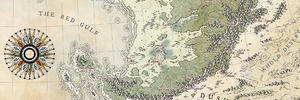
). So although the elevation map is a very time consuming project, one can't help but feel a degree of satisfaction when looking at the difference between the two maps (that is, before everyone posts that they actually prefer the old version). Anyway, that's it for this update, comments are welcome as usual, and hopefully I'll have an update on Menorias in the not-too-far-out future.

    Edit:
    Apparently I drew the EAFC as a dextral (right-lateral) transform fault here (it should actually be sinistral like in the original map of the tectonic features).
    Last edited by Charerg; 07-31-2020 at 08:36 AM.

  3. #133
    Guild Artisan Charerg's Avatar
    Join Date
    Feb 2015
    Location
    Finland
    Posts
    525

    Default The Map so far...

    As another status update, I've now finished redoing the coastlines of Menorias (northern portion of Eocidar). I realised I haven't posted the world map in a while, which has undergone some major changes since its previous iteration. So I thought this might be a good time for that:

    Click image for larger version. 

Name:	Aduhr VI.png 
Views:	108 
Size:	2.72 MB 
ID:	124382

    The southeastern region has been basically compeletely redone (and as can be seen here, the shapes and coastlines are still WIP in those areas). A new micro-continent (Balarr) has also been added with a somewhat uncertain tectonic history. As far as the rest of the map goes, Nemeias is largely finished, apart from some final touch-up in a few places, and I'll probably update the coastlines of the polar continents after the elevations for Menorias are done. Still a lot left to work on, but with most of Eocidar now finished, it doesn't look quite as daunting anymore .

  4. #134

    Default

    Wow, those are some big changes! Did you have to majorly revise your tectonic model to accommodate all that?

    The elevation maps for Eocidar, Menorias, and Akanrias look absolutely fantastic--looking forward to seeing the evolution of the other regions

  5. #135
    Guild Adept Harrg's Avatar
    Join Date
    Apr 2011
    Location
    Russia. Россия
    Posts
    304

    Default

    It is impressive. How will u think work with northen and southen poles?

  6. #136
    Guild Artisan Charerg's Avatar
    Join Date
    Feb 2015
    Location
    Finland
    Posts
    525

    Default

    Quote Originally Posted by Harrg View Post
    It is impressive. How will u think work with northen and southen poles?
    The same way I work on basically everything beyond the 30 N/S latitudes: reproject the area to equirectangular oblique centered on the region I'm working on, then project back to equirectangular once finished. I've found that this method removes most of the projection-induced inaccuracies, while it's easy to project the eq. oblique back to regular equirectangular. For example, here's Menorias projected to eq. oblique (centered on -90 E° and 35 N°), and clipped from the world map:

    Click image for larger version. 

Name:	Sample.png 
Views:	67 
Size:	480.2 KB 
ID:	124395

    Quote Originally Posted by MrBragg View Post
    Wow, those are some big changes! Did you have to majorly revise your tectonic model to accommodate all that?

    The elevation maps for Eocidar, Menorias, and Akanrias look absolutely fantastic--looking forward to seeing the evolution of the other regions
    I did update the tectonic model a while back, though at that point I already had most of the revisions in mind, so in a sense I didn't have to change the tectonics (since I already built the tectonic model to represent the updated map before redrawing the coastlines). I guess my latest tectonics overview has become quite outdated, and I should probably post an updated one at some point. Though most of the plate movements remain similar, just more refined and with more of the details worked out. I guess the big change is that Anapar, which used to be a continent, has now collided with Nemeias (forming that large horn-shaped peninsula). Instead of Anapar I now have the aforementioned Balarr as a new micro-continent in the SE quadrant of the world map, however Balarr will have a different tectonic origin (and that hasn't really been defined yet). Here's how the tectonic model (so far) looks at 0 Ma (not quite up-to-date when it comes to position of Balarr and the coastline of eastern Nomune):

    Click image for larger version. 

Name:	0 Ma.png 
Views:	89 
Size:	3.17 MB 
ID:	124396

    And as an example of some of the details, here's Nomune at 50 and 20 Ma, respectively. I used to have the minor sea opening between the island of K'yatahi and mainland Akanrias at ca. 300 Ma, but in the updated tectonic model it makes more sense that this is a recent event. The continent of Nomune changes direction from a southern vector to a more southwesterly course at 50 Mya, and as part of this movement, K'yatahi detaches from Akanrias. This is actually something that isn't reflected in the topography yet (since the mountains surrounding the sea would be expected to be taller now that they've been formed much more recently).

    Click image for larger version. 

Name:	Screen_tectonics.png 
Views:	77 
Size:	3.21 MB 
ID:	124397
    Last edited by Charerg; 08-23-2020 at 06:47 PM.

  7. #137
    Guild Artisan Charerg's Avatar
    Join Date
    Feb 2015
    Location
    Finland
    Posts
    525

    Default Update on Menorias

    Work on the elevation map for Menorias has now passed the low-res stage. After attempting to skip the low resolution phase with Central Eocidar, I learned the hard way just how much work you can save by spending the time and effort to create a good low resolution map. For me, the problem with working at higher resolutions with my elevation maps has always been that I tend to focus too much on the little details, and then if the "big picture" isn't in a finished state yet and I make some changes, all that work spent on sculpting out the small details gets thrown in the bin...

    So having learned from my past misfortunes, I started out working on Menorias at extremely low resolution (300x277). And with that stage now finished, here's the result upscaled to mid-res (600x554) and passed through Wilbur:

    Click image for larger version. 

Name:	Menorias post-lowres.png 
Views:	107 
Size:	111.6 KB 
ID:	124937

    Considering that I spent around two years working on C. Eocidar, progress on Menorias has been quite rapid so far. We'll see if I'll be able to keep this up !

  8. #138
    Professional Artist ThomasR's Avatar
    Join Date
    Nov 2015
    Location
    Angers, France
    Posts
    4,152

    Default

    Those shapes are mesmerizing ! I cannot give insight as it's not really my area of expertise but it is beautiful.

  9. #139
    Guild Artisan Charerg's Avatar
    Join Date
    Feb 2015
    Location
    Finland
    Posts
    525

    Default

    New year, and here comes a new update on Aduhr. I've finished the mid-res stage for Menorias, leaving only the high-res stage left to do until the subcontinent is finished (and also the whole continent, as this is the last piece). Here's how the map looks like (straight out of Wilbur pretty much):

    Click image for larger version. 

Name:	Menorias post mid-res.png 
Views:	86 
Size:	354.5 KB 
ID:	127666

    I think I'll complete the polar continents before moving on to the climates (the original plan being that I would map first the topography, then the climates, on a continent-by-continent basis). Since Eocidar and Urgaleon are essentially part of the same landmass, it makes sense to lump them together for the purposes of working out the climates.

  10. #140
    Guild Artisan Charerg's Avatar
    Join Date
    Feb 2015
    Location
    Finland
    Posts
    525

    Default Menorias finished

    Time for another of what seems to be bi-annual updates on Aduhr. So, I've finally finished Menorias, completing the continent of Eocidar (hooray!). Here are the maps:

    Elevations:
    Click image for larger version. 

Name:	Menorias I.png 
Views:	34 
Size:	357.0 KB 
ID:	130595

    Gradual (with bump map):
    Click image for larger version. 

Name:	Menorias II.png 
Views:	45 
Size:	1.25 MB 
ID:	130594

    Unlike the previous maps, I spent the effort to remove the artifacts produced by Wilbur (essentially doing a lot of manual blurring post-Wilbur). As a result, Menorias has more of a "smooth finish". Previously I decided to leave the artifacts to add a bit of "randomness" to the map, though in hindsight I think I prefer the cleaner look. If you don't know what I'm referring to, here's a great post by Waldronate going over the limitations of Wilbur.

    Next up, after adding Menorias to the world map and doing a lot blurring and a bit of touch-up in the already completed regions, I'll start work on the coastlines of the polar landmass (the continent of Urgaleon). I think I'll first sculpt the non-glaciated topography, then add the glaciers in afterwards (although I'll have to take the isostatic depression caused by the massive ice sheets into account there).
    Last edited by Charerg; 07-23-2021 at 07:11 AM.

Page 14 of 17 FirstFirst ... 41011121314151617 LastLast

Posting Permissions

  • You may not post new threads
  • You may not post replies
  • You may not post attachments
  • You may not edit your posts
  •