Excellent idea for an adventure scenario!! Can't wait to see how the maps look!


This is a great idea for a challenge, and it so happens that I've had an idea for something along those lines knocking around in my head for a while.
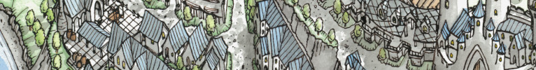
I'm mapping the same physical location... separated by 500 years. The topmost map will show this portion of the world as it was when the Orcish kingdoms were fragmented and warred amongst themselves as often as they did against the Manrealms and the great forest city-states of the Elven Courts. The bottom map shows the same places five centuries later, after the formation of the Orcreich and its almost complete domination of the area. The Door In Time is a floating ring of stone discovered by an Elven merchant-explorer deep under a ruined city in the southwestern mountains. To his horror, when he stepped through it, he discovered that his people had been almost completely annihilated and the Orcish imperium reigned supreme.
His task is to find out how this happened and try to prevent it - but a rival party of Orcs is not far behind his trail and if they discover the Door, Orcish domination for eternity is all but certain...
### Latest WIP ###
Excellent idea for an adventure scenario!! Can't wait to see how the maps look!
My Battlemaps Gallery http://www.cartographersguild.com/al...p?albumid=3407
The layering of two places ( or the same place at two times? ) is really cool! Can't wait to see how you decide landscapes and borders are going to get changed!
The lake separating the three factions should make for a fun environment to strategize through. A good start!
IR
I'm trying to get the main geography done fast so I have time to think about, as Paritegic said, how the borders will change. One thing for sure is that the lakes in the Elven forests are gone (and so are the forests...).
Decided to use KM Alexander's excellent brush set for the mountains. Probably one of the best sets I've ever seen.
### Latest WIP ###
Last edited by Diamond; 06-09-2021 at 11:49 PM.
I'm not convinced the color-coded nation names work, but meh, it's okay for now. Will likely change.
### Latest WIP ###
I like the colors. And the dots on the coast lines are great.
I totally second Fol2Dol here, both for the font color and dots. It's good to see you map, Diamond ! ^^
I changed the labels - I think it unifies the whole thing a little more. I kind of feel like the colored labels were too dominating.
I'll add a key eventually, but the reddish, wavy-line areas are Non-Aggression Pact Zones. Think several WW2 Casablancas with Orcs, Humies, and Pointy-Ears mingling.
### Latest WIP ###
Last edited by Diamond; 06-12-2021 at 07:56 PM.
Looking good, I like the font you've used for the top map. I'll be interested to see how this progresses.
View my map and asset packs on CartographyAssets or DrivethruRPG. Support my work on Patreon. Take a look at my work on my Website or Instagram.
 Posting Permissions