Results 1 to 10 of 17

Thread: The World of VAYU

Hybrid View

Previous Post Previous Post   Next Post Next Post
  1. #1
    Guild Master Facebook Connected - JO -'s Avatar
    Join Date
    May 2016
    Location
    Geneva, Switzerland
    Posts
    2,844

    Default

    Looking forward to see it colored ! You’re right about the difficulty to read it in black and white, unless you zoom in, then it’s a beauty, with so many details !

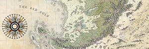
    I love your display, the empty space in the middle with the compass catch the eye and invites us to visit the different parts. The ice up north covering the frame is a good move too !

    I understand you work with a Mac, is that right ?

  2. #2
    Professional Artist ThomasR's Avatar
    Join Date
    Nov 2015
    Location
    Angers, France
    Posts
    4,153

    Default

    Quote Originally Posted by - JO - View Post
    Looking forward to see it colored ! You’re right about the difficulty to read it in black and white, unless you zoom in, then it’s a beauty, with so many details !

    I love your display, the empty space in the middle with the compass catch the eye and invites us to visit the different parts. The ice up north covering the frame is a good move too !

    I understand you work with a Mac, is that right ?
    Thanks Joel I saw Wingshaw do something similar with a border and wanted to try it. I do work with a MacBook Pro indeed.
    Quote Originally Posted by Voolf View Post
    The map is cool, but i dont really like the font. Very hard to read :/
    Thanks Voolf but, client's choice. He wanted something futuristic and that's the one he chose between my propositions. I upped the kerning to get more legibility but you are right, it can be difficult to read sometimes. I might try something with the color version.

    Quote Originally Posted by Abu Lafia View Post
    Hey Thomas, looking great already! I love the shape of your continents, but have to nitpick about the double "shore lines" around the landmass. I think it's a bit too confusing in this scale (and ofc in b/w), especially with the island chains /archipelagos being partly smaller than the distance between the two lines (hope you get what i mean by it ). Looking forward to see the coloured and ornamented version of it!
    Thans Martin The shore waves were a lazy man's choice. the best way, given the scale would have been radial waves but I hate to use digitally generated ones and the aim was color so, I drew what took the less time even if it's not the best idea. In the color version, thos wave will disappear completely.

    Quote Originally Posted by MapMappingMapped View Post
    Very nice map! Hope you get it colored fast
    Thanks MMM ! It'll be some time unfortunately

Posting Permissions

  • You may not post new threads
  • You may not post replies
  • You may not post attachments
  • You may not edit your posts
  •