
 Reply With Quote


I can see the city sprawl pretty well on this picture. Or am I missing something?
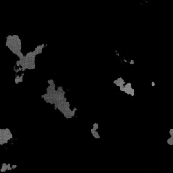
The gray area is downtown Philadelphia, the surrounding is the suburban area and the rest is the countryside/other smaller cities.


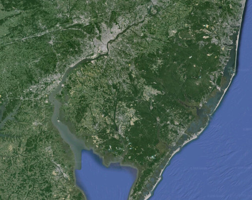
Does anyone have any suggestions on how to make a map where one can see "zoomed out" city sprawl? Here's an example from Google Maps (Philadelphia & southern New Jersey, to be exact).
It's entirely possible there is a tutorial or something I missed.
Thanks!
I can see the city sprawl pretty well on this picture. Or am I missing something?
The gray area is downtown Philadelphia, the surrounding is the suburban area and the rest is the countryside/other smaller cities.
If you mean how do I represent an abstraction of a city sprawl, then brushes are quite useful (not sure what sort of software you use but brushes are used in photoshop and similar software). What you do is have little rectangles in your brush, which you use to give the edges of the city shape some sort of 'city edge blockiness' It's by no means a perfect way to it but it gets you part of the way there. It also has a lot to do with scale. At the scale of the map you've shown the city structure is more like neurons in a brain - you can see the ribbon development along roads and the spread (at this scale) is not blocky although there is some there. It also really depends on the look and feel you want your map to have. Are you after the satellite look of the map you've shown or are you after a different look? If different, can you post a picture of a map which has a similar look and it will make it much easier for us to give you advice.
best
Ravs
here on "the Earth" cities are CONCRETE
so cities are grayish and tend to be on FLAT land ( ever tried to pour cement on a slope ??? it is not fun )
You are going to have to explain that , it is very ambiguous .a map where one can see "zoomed out" city sprawl?
--- 90 seconds to Midnight ---
--------
--- Penguin power!!! ---
I was extremely unclear in my OP. Sorry about that. So, to clarify:
I put photo-realistic in scare quotes intentionally. This site has some excellent tutorials on how to make forests and mountains, and IIRC, the term "photo-realistic" was used in a few of them. However, in retrospect, I probably shouldn't have used the term here. If anything, maybe I should have used the term "hyper-realistic", since the images are more detailed and interesting than an actual satellite photo would be. Mountainous peaks and valleys don't have as much detail as a fun map here shows, and there is more texture to forests on maps you can produce in GIMP than you'd see on a satellite image.
This is when I need to point out another thing: the pic I posted is not something I made, but rather a screen capture from Google Maps. I posted it as a reference of something. In retrospect, this was a profoundly bad idea, especially with the lack of comments on my part. I honestly have no idea what I was thinking.
Anyhow, as johnvanvliet pointed out, contemporary cities are a massive amount of flat concrete, and I suspect ancient cities were likely almost monochrome as well. However, that doesn't mean there is no detail: If you look at the image I posted, you can see how the sprawl spreads out in web like patterns along major roads, making larger clumps at intersections. If it was a little bit more zoomed in, you would also see lots of grids, often misaligned with one another; some would be organized around the cardinal directions, others not. That's the detail I'd be interested in reproducing, the mishmash of urban grids mixing with a network of roads.
I am curious if there are any tips on how to do that.
...I hope I'm making more sense this time. Sorry about before.
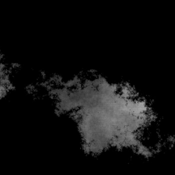
one way is to add a canvas texture
a quick 1 min. example
or a different canvas pattern
using Gimp and the Gmic plugin
Last edited by johnvanvliet; 03-04-2016 at 07:51 PM.
--- 90 seconds to Midnight ---
--------
--- Penguin power!!! ---
 Posting Permissions