Reply With Quote


Well, that's already quite impressive I'd say. The satellite view and globe are quite really pleasant. It's a very green world, I suppose?
I really like your work on history and the land shapes in general.


Around the beginning of this year I came to CG with a "How Do I" question about conworld building; thanks to CG I determined I wasn't able to help a potential client with his fantasy world. The idea kept nagging at the back of my mind though, so over this past month (September) I spent a bit of free time designing a fictional world for fun. Since CG was so helpful I figured I should say thank you by sharing.
WIP since I'll likely continue expanding on it with other related side projects in my free time. Original idea was to do a series of maps from a variety of time periods; early history, modern history, futuristic, etc. More of a science-fiction than fantasy person myself; so I opted for the common fantasy species but I wanted to roll them back to their mythological concepts instead of their modern, post-Tolkien, high-fantasy versions and rebuild them from the ground up to be more believable as a mental exercise in pseudoscience. Ultimately it's just a skills/tools practice so who knows how far i'll actually get with it.
Initial world was generated in Fractal Terrains, edited & eroded in Wilbur, then the satellite image look was done using GIMP. Cloud cover is an edited version of the Blue Marble public domain imagery. I dropped the whole thing into Blender for fun and made a low-framerate GIF animation. Scaled everything down to reasonable posting size.
Hope you enjoy!
Blender globe low-frame animation (Pre-history)
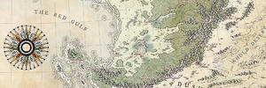
GIMP satellite imagery, no clouds (Pre-history)
Evolutionary ladder of modern species (1990s/Modern Textbook Style)
Migration of modern species (1990s/Modern Textbook Style)
WIP for what will be political map in (1990s/Modern Textbook Style)
Well, that's already quite impressive I'd say
I really like your work on history and the land shapes in general.
Thanks for the compliment! I was disappointed that I didn't have time to learn G-Plates, and the plate tectonics are really very limited, but if there's no huge glaring problems then I can be happy with that.
The theory was this satellite view is at the height of the summer season, when all the fauna is in full; I’d eventually like to do a peak of the winter season imagery also. The fauna that has evolved has a slightly darker color than Earth due to atmospheric composition and distance from its F class star. The autumnal colors will also vary a bit from Earth. I haven’t worked out the solar system map entirely, and due to life this project is getting pushed to the bottom of the list for at least a few months or more.
Last edited by LordIndy; 09-30-2017 at 06:29 PM.
Very impressive!!!
Thanks zhar2, glad you like it!
Addendum: I just realized a typo in the Evolution diagram, all instances of the word "Age" should be "Ago".
Had some inspiration while working on another gig so I came back to this project. Roughed out a couple more graphics, all feedback/criticism is welcome. Once again, scaled down to reasonable posting size.
Hope you enjoy!
WIP Ocean Currents Map (1990s/Modern Textbook Style) - This one needs names and some refinements.
WIP Stellar System Diagram - Basically a rough draft, nothing to scale, missing 2nd planet which will be a "super earth" semi-habitable world, barely started work on asteroid belt, moon needs shading, overall refinement and labeling.
Last edited by LordIndy; 09-30-2017 at 06:49 PM.
Hi Indy, it´s definitively quite interesting, I always loved maps with backgrounds, ideas and history !!
Thanks randigpanzrall, hopefully I'll get more free time to come back to it in the near future. The historical maps are definitely a priority, just have to finish pounding out the science-esk stuff first.
WIP Plate Tectonics Map (1990s/Modern Textbook Style), very much unfinished at the moment.
The result on the globe is fantastic, great job !
Some bits of your tectonics map are very good, namely, how it seems that there's a continental plate moving north and startig to shut down that oceanic ridge.
Yet, one aspect is less likely: The ocean/continent subduction on the top left side of the map has the concave/convex sides switched.. (see Chile's or Japan's coasts for reference)
however, since it's an area quite far north, the projection doesn't help. Have a look at that area on an orthogonal projection (you can use g.projector, which is free software) for that.
 Posting Permissions