Page 2 of 17 FirstFirst 12345612 ... LastLast
Results 11 to 20 of 166

Thread: unexplored Lands

  1. #11
    Guild Expert
    Join Date
    Jan 2016
    Location
    Canada
    Posts
    1,499

    Default

    Thanks Selden, I'll have to look into that link a little further when I get more time later today, but when I've looked into GIS packages before they just baffle me completely so I'm hoping to avoid that learning curve, it seems though that I may not have a choice. I'm starting to feel a little overwhelmed by all the learning involved in making this type of map.

  2. #12

    Default

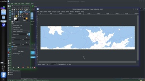
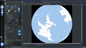
    For your amusement, here's what happened when I used MMPS (under Cygwin) to project the south pole in gnomonic (where one could make appropriate changes, but I didn't)

    Click image for larger version. 

Name:	south_pole.jpg 
Views:	49 
Size:	400.3 KB 
ID:	98789

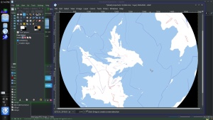
    and here it is reprojected to equirectangular. One could then use appropriate tools to merge it with the original artwork, although MMPS could do that for you, too.

    Click image for larger version. 

Name:	eq_south_pole.jpg 
Views:	69 
Size:	405.8 KB 
ID:	98790

    Here's the script that I used.

    Code:
    #! /usr/bin/sh -x
    #
    # project equirectangular to gnomonic
    #
    convert detail_colored.jpg tmp.ppm
    project \
        gnomonic \
        -scale 2 -lat -90 -long 0 -w 2500 -h 2500 \
        -f tmp.ppm >tmp2.ppm
    convert tmp2.ppm south_pole.jpg
    #
    # project gnomonic to equirectangular
    #
    project \
        -i gnomonic \
        -scale 2 -lat -90 -long 0 -w 5000 -h 2500 \
        -f tmp2.ppm >tmp3.ppm
    convert tmp3.ppm eq_south_pole.jpg
    "project" is the MMPS re-projection utility and "convert" is the ImageMagick image format conversion utility.

    p.s.
    Note that .ppm is a lossless, uncompressed image format. Of course, any intermediate editing should be done in a similarly lossless image format like png or bmp, for example, using a lossy format like jpg only for the final image.
    Last edited by selden; 08-24-2017 at 05:23 PM.
    Selden

  3. #13
    Guild Expert johnvanvliet's Avatar
    Join Date
    Jul 2012
    Location
    N 42.39 W 83.44
    Posts
    1,091
    Blog Entries
    4

    Default

    also for JUST fixing a polar pinch .
    The Gimp has had a built in tool for 20 years , to remap to polar and back .


    crop


    map southpole


    zoom in


    fixes ( resynthesizer plugin


    remaped back


    .
    Last edited by johnvanvliet; 08-24-2017 at 06:20 PM.
    --- 90 seconds to Midnight ---
    --------

    --- Penguin power!!! ---


  4. #14
    Guild Expert
    Join Date
    Jan 2016
    Location
    Canada
    Posts
    1,499

    Default

    Wow guy's! I can't believe you took the time to do all this, I really appreciate it, and it's neat to see it this way. Thank you so much!

    Quote Originally Posted by selden View Post
    Here's the script that I used.

    Code:
    #! /usr/bin/sh -x
    #
    # project equirectangular to gnomonic
    #
    convert detail_colored.jpg tmp.ppm
    project \
        gnomonic \
        -scale 2 -lat -90 -long 0 -w 2500 -h 2500 \
        -f tmp.ppm >tmp2.ppm
    convert tmp2.ppm south_pole.jpg
    #
    # project gnomonic to equirectangular
    #
    project \
        -i gnomonic \
        -scale 2 -lat -90 -long 0 -w 5000 -h 2500 \
        -f tmp2.ppm >tmp3.ppm
    convert tmp3.ppm eq_south_pole.jpg
    "project" is the MMPS re-projection utility and "convert" is the ImageMagick image format conversion utility.

    p.s.
    Note that .ppm is a lossless, uncompressed image format. Of course, any intermediate editing should be done in a similarly lossless image format like png or bmp, for example, using a lossy format like jpg only for the final image.
    Selden, this goes way beyond what I'm capable of, the longer I look at it the stupider I feel... I would have to pay you to do this for me because I don't understand a word of it.

    Quote Originally Posted by johnvanvliet View Post
    also for JUST fixing a polar pinch .
    The Gimp has had a built in tool for 20 years , to remap to polar and back .


    crop


    map southpole


    zoom in


    fixes ( resynthesizer plugin


    remaped back


    .
    Johnvanvliet, this one made a little more sense, and I wondered if I could do something similar in PhotoShop, and it turns out I can I was even able to save it out as an obj and import it into zbrush, and I'm thinking if I redo the uv seams then I can get all the areas I need flattened out for regional sections without distortion. I had no idea what PhotoShop could do in 3D so I was pretty surprised to find this out just playing around tonight.

    I also found that I can export heightmaps out on a sphere from PhotoShop, or on a flat plane, and import them easily to zbrush where I can use the map as a displacement so I think theres some room for experimentation there too.

  5. #15

    Default

    Well, I use Paint.Net and I'm not at all familiar with Zbrush, so I guess we're even.
    Selden

  6. #16
    Guild Expert johnvanvliet's Avatar
    Join Date
    Jul 2012
    Location
    N 42.39 W 83.44
    Posts
    1,091
    Blog Entries
    4

    Default

    i use blender and not zbrush but for heightmaps they really do need to be 16 bit or 32 bit float grayscale images
    gimp2.8 is ONLY 8 bit
    now
    Gimp 2.9 DEVELOPMENT can work with 16 bit and 32 bit data
    ( so can photoshop, but they are using a monthly fee )

    as i recal PS has a similar plugin

    as for time , that only took 15 min while watching the news and i bet selden took the same amount of time
    --- 90 seconds to Midnight ---
    --------

    --- Penguin power!!! ---


  7. #17

    Default

    I took a little longer than that because I wanted to provide a readable script. I prefer to use command-line software instead of GUI software when I can, if only because operations are exactly reproducible no matter what the input image looks like. When I do things visually I can never get things to come out the same way twice, and it can be a royal pain if I'm near the end of a multi-step procedure and discover I messed something up near the beginning.
    Selden

  8. #18
    Guild Expert
    Join Date
    Jan 2016
    Location
    Canada
    Posts
    1,499

    Default

    Quote Originally Posted by selden View Post
    Well, I use Paint.Net and I'm not at all familiar with Zbrush, so I guess we're even.
    I've never tried Paint.net before but looked into it just now after reading this comment so I may have to give it a try. I do use Gimp sometimes though because there are a few things it can do that PhotoShop can't.

    Quote Originally Posted by johnvanvliet View Post
    i use blender and not zbrush but for heightmaps they really do need to be 16 bit or 32 bit float grayscale images
    gimp2.8 is ONLY 8 bit
    now
    Gimp 2.9 DEVELOPMENT can work with 16 bit and 32 bit data
    ( so can photoshop, but they are using a monthly fee )

    as i recal PS has a similar plugin

    as for time , that only took 15 min while watching the news and i bet selden took the same amount of time
    I know I can do 16 and 32 bit images but I'm not sure what you mean by float? This is sort of new territory for me, I'm used to just trying to make things look pretty so when I get to the height map part of it I'm going to be pretty lost I think. And then there's figuring out the climate omg I'm starting to wonder what I've gotten myself into. I'm still just trying to figure out all this projection stuff, at this point I've completely given up on trying to add any coastal detail, I'm just trying to make shapes that work without distorting too much in each projection, and it's taking forever.

    Quote Originally Posted by selden View Post
    I took a little longer than that because I wanted to provide a readable script. I prefer to use command-line software instead of GUI software when I can, if only because operations are exactly reproducible no matter what the input image looks like. When I do things visually I can never get things to come out the same way twice, and it can be a royal pain if I'm near the end of a multi-step procedure and discover I messed something up near the beginning.
    So many times I've done something in PhotoShop and not been able to reproduce it and it is frustrating.

    This might be a stupid question, but do you need a special programme to run these scripts? I wouldn't even know where to plug them into, it would be nice to try some of them because I have run across tutorials using them before but had no idea how to even start. Theres also been data that I wasn't able to get because I just didn't even know how to open it, so when I'm searching for height maps of earth and other mapping images I always have to search for things that are already converted into other formats and this usually means low resolution.

    What is the best way to view dem data set's? Is there any gis software that's easy to use and understand?

    I hadn't originally intended to project this onto a globe, but now that I've been playing around with it it's kind of fun to see things develop as they would on an actual planet. It really changes the way I look at map making. Unfortunately I'll have to make allot of ugly maps before I'm able to get anything that's even half way appealing to look at.

  9. #19
    Guild Expert johnvanvliet's Avatar
    Join Date
    Jul 2012
    Location
    N 42.39 W 83.44
    Posts
    1,091
    Blog Entries
    4

    Default


    This might be a stupid question, but do you need a special programme to run these scripts?
    maybe
    that is a bash shell script
    win 10 is suppose to be able to run a bash terminal - but seeing as a DUMPED microsoft in 2005 ??? i do not know

    a bash or csh shell is not really complex - just a normal everyday text based interface to the Operating system
    MATLAB now that is a pain in the rear end ( matlab runs on windows and apple and linux )

    for earth DEM's a lot are in ArcGis format or in 16 bit signed tiff or raw ( -32767 to + 32768 values )
    normally i use GDAL for that type of data

    do not worry too much i have been at this for 20 years so
    digital imaging data is a bit complex
    --- 90 seconds to Midnight ---
    --------

    --- Penguin power!!! ---


  10. #20

    Default

    Quote Originally Posted by kacey View Post
    I've never tried Paint.net before but looked into it just now after reading this comment so I may have to give it a try. I do use Gimp sometimes though because there are a few things it can do that PhotoShop can't.
    Unlike John, I actually do relatively little with planetary surface maps. I'm more into (relatively simple) 3D models and star distributions and writing my own programs to help with the problems I encounter with those. As a result, the GUI software that I tend to prefer is the kind that has a relatively short learning curve. That's one of the reasons I prefer Paint.Net to Gimp and Anim8or to Blender, even though they aren't as sophisticated.

    I know I can do 16 and 32 bit images but I'm not sure what you mean by float?
    "Float" is short for "floating point numbers." It's how computers represent non-integer values using (usually) 32 or 64 bits. It lets you represent colors or height values with a much larger range but somewhat less precision than 32 bit integers can provide.
    This is sort of new territory for me, I'm used to just trying to make things look pretty so when I get to the height map part of it I'm going to be pretty lost I think. And then there's figuring out the climate omg I'm starting to wonder what I've gotten myself into. I'm still just trying to figure out all this projection stuff, at this point I've completely given up on trying to add any coastal detail, I'm just trying to make shapes that work without distorting too much in each projection, and it's taking forever.
    All of the topics you mention can be studied to as great a depth as you want. It's easy to get lost in the details. Sometimes it pays to back off so you can decide which aspect of a design you really want to concentrate on and try not to let yourself be distracted too much by other aspects.

    So many times I've done something in PhotoShop and not been able to reproduce it and it is frustrating.

    This might be a stupid question, but do you need a special programme to run these scripts?
    Yes.

    That script is the equivalent of a Windows .BAT file, but written for use with the Bash command shell instead of the Windows COM language.

    In my case, I'm using Cygwin under Windows 7 for access to Bash, MMPS, ImageMagick and many other utilities. (Cygwin also works under other versions of Windows, including Windows 10.) It provides an interactive environment which is very similar to Linux, including a variety of shell command languages. The Bash script that I provided above contains several instructions to Windows, telling it to run the programs convert and project. Their command lines include qualifiers which tell those programs which image files to process and what to do to them.

    As John mentioned, Microsoft has developed their own equivalent to Cygwin for Windows 10 (but initially based on Ubuntu) which supposedly will be provided as part of the Fall Creators Update. Right now it's available as a developer's Beta test for those in the Insider program. In principle the script that I provided should work fine with that.
    I wouldn't even know where to plug them into, it would be nice to try some of them because I have run across tutorials using them before but had no idea how to even start. Theres also been data that I wasn't able to get because I just didn't even know how to open it, so when I'm searching for height maps of earth and other mapping images I always have to search for things that are already converted into other formats and this usually means low resolution.
    Yup, it can be frustrating at times.
    What is the best way to view dem data set's? Is there any gis software that's easy to use and understand?
    It's been a while since I did anything with DEMs, but 3DEM has been a favorite of mine. Although the original Web site is gone, it's still available with a little searching. Some info and a Windows installer is available at http://www.hangsim.com/3dem/
    I hadn't originally intended to project this onto a globe, but now that I've been playing around with it it's kind of fun to see things develop as they would on an actual planet. It really changes the way I look at map making.
    That's very much the case for me, too.

    Click image for larger version. 

Name:	capture_006_26082017_061617.png 
Views:	56 
Size:	175.4 KB 
ID:	98812

    (I like to use Celestia to view planets in 3D.)

    Unfortunately I'll have to make allot of ugly maps before I'm able to get anything that's even half way appealing to look at.
    Take your time and enjoy the work as much as you can. Baby steps!
    Selden

Page 2 of 17 FirstFirst 12345612 ... LastLast

Tags for this Thread

Posting Permissions

  • You may not post new threads
  • You may not post replies
  • You may not post attachments
  • You may not edit your posts
  •