Reply With Quote
Thanks Waldronate, this is really helpful!

Wilbur doesn't update the UI like it should while it's doing the initial flow computations. Those computations are a bit more than O(n*n*n) (the time taken is on the order of the square of the number of pixels), so larger surfaces take much longer than you would expect. As an example, if we define a 1000x1000 pixel surface (1M pixels) to take 1 time unit, then a 2000x2000 pixel surface (4M pixels) would take more than 16 times as long. There are also effects relating to the total length and complexity of river channels. The short answer is to wait. Sometimes you'll need to wait 10 minutes or more, during which the OS will whine about the program not responding. If the Wilbur CPU usage is remaining consistent (Ctrl+Shift+Esc to bring up task manager) during the find rivers operation, then it's probably still doing useful work. There are also a couple of size breakpoints where the speed will dramatically slow: surfaces larger than the CPU cache that require fetching from main memory and surfaces larger than main memory that require fetching from disk. Wilbur isn't very smart about how it manages memory, so it tends to be pretty sensitive to switching to slower storage.Originally Posted by kacey

I will admit to having very little patience at the best of times, so I don't do well waiting for the program to finish its work on large surfaces. I developed the multi-resolution techniques described at https://www.cartographersguild.com/a...chmentid=80066 to try to reduce my total waiting time. The main elements get roughed in at the lower resolutions to where you're happy with them and then the details can be etched on top of that. How small you want to start with depends entirely on your level of patience. I tend to start out small and chop in things where it's only taking a few seconds to process on my elderly i7-3770. The surface has a somewhat different appearance than one eroded fully at the higher resolution, but I'm willing to live with spending a total of 15 minutes or so rather than 15 minutes or so per iteration. Then again, I usually don't care too much about smaller details, either...
Thanks Waldronate, this is really helpful!
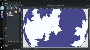
I still have quite allot of work to do before I'm fully satisfied with this coast, but I thought I'd post an update of where I'm at with it. I'm just trying to get things cleaned up a little right now, but I think I have the basic shapes in place. I'm having some resolution issues with the left most continent, I think I accidentally scaled it up a touch with the free transform tool when I was moving it, but I'm not too worried because I'll have to do the lines again anyways. And these colours are just placeholders for now until I decide on a style.
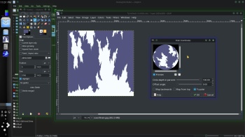
And I threw it into G.Projector so you can see the distortion. I tried to tell myself I didn't care, but I do so I still have a bit of tweaking to do at the poles.
Let me know if you see any glaring issues, or if there's areas that just don't seem right. I'm thinking that these continents might be a little big, especially the one on the left. I'm hoping to get this part over with soon so I can start adding more details, and islands and get moving on the elevation. I really have no idea where the plates should be or how to place the mountains so any ideas on that would be really helpful.
Last edited by kacey; 09-13-2017 at 01:08 AM.
just a bit on the south pole
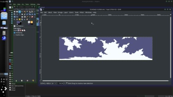
an example -------------------------------------------------- Then fixed
remapped back to Simple Cylindrical

--- 90 seconds to Midnight ---
--------
--- Penguin power!!! ---
Maybe it would be easier if you didn't try to draw the map as an equirectangular map at all to start with, but used that azimuthal projection as the 'master'? I think you're creating something really beautiful, but at the same time I also think you are making it more difficult for yourself than it really needs to be by working on it in equirectangular. Maybe turn the work method inside out and start with the azimuthal, then produce an equirectangular from the azimuthal?
I'm awake in the middle of the night (again!), so I'm a bit hazy and disorganised about reading right the way back through the thread, but I think I remember you saying you were only doing the outline as a world map, then working on the regions separately. If that's the case, then the equirectangular isn't something you really need to worry about till right at the end of the process, and only then so that you can produce an image that you can wrap around a globe in 3D view in any of the more common apps that allow you to do that.
Free parchments | Free seamless textures | Battle tiles / floor patterns | Room 1024 - textures for CC3 | GUILD CITY INDEX
No one is ever a failure until they give up trying
Thanks Chashio, I'd love to see that first map.
Thanks Johnvanvliet, I really appreciate that you take the extra time to do this, it's really nice. You seem to be able to get the poles looking better then then I can. I'm finding it very frustrating, every time I change them then something else needs adjusting and getting the coast finished has become a real chore... Would you mind if I used you're version, or something very similar on the map? I really like that you've made it work without changing the basic shape too much which is something I haven't been able to accomplish yet.
G.Projector only lets me import a few projections, I have gone back and forth a few times with the Robinson, and winkle triple though it still has some major distortion in those. How would I go from Azimuthal back to equirectangular? Is there software that can do this?
I do want to do smaller regional maps, and continent maps as well, and city's too. I would like to have a world that I can build in, and create characters, and histories, and possibly do some landscape paintings too, but first I need some basic maps. I would like my elevation, and climate maps to be in equirectangular or Robinson just because when I see other maps like that I really like how they look, and it's what I'm used to seeing when I'm looking at maps of earth.
Here's what I need before I will feel ready to start tracking the migration of people around this planet, which is my big goal right now...
A finished coast line
Elevation map
Climate map
And a map showing where different resources are.
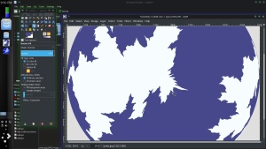
I've started doing some work on elevation on the top right continent, but mostly just testing style at this point, I'm a little torn on what size I should be working with for a map like this. I'm used to doing regional maps so I'm getting a little confused about the scale of things and I'm still not happy with the land masses on the left hand side.... There's just something bugging me about them.
Hmmm. I see your problem there.
Maybe someone else knows an app that will work with it in reverse?
Free parchments | Free seamless textures | Battle tiles / floor patterns | Room 1024 - textures for CC3 | GUILD CITY INDEX
No one is ever a failure until they give up trying
gimp has had a built in tool for at least the last 17 years , if not 20
under distorts " polar coordinates "
you can remap to the north or south pole
fix it
remap back to simple cylindrical
crop the south and rescale to a square
south pole fixed using "resysenthizer " inpainting tool ( or you can just redraw it )
remap back with the built in tool
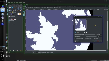
resize back to the original size
--- 90 seconds to Midnight ---
--------
--- Penguin power!!! ---
I believe there is a tool/app still floating around here somewhere... it's called ReprojectImage. I asked about being able to do a similar function because I like to sketch worlds in azimuthal, etc. and was directed that way. But it's not for huge images or final renders... you'd have to redraw from the example, and there may be easier options, like what john shows.
https://www.cartographersguild.com/s...l=1#post197147