Page 2 of 2 FirstFirst 12
Results 11 to 19 of 19

Thread: Tectonics, weather and other processes

  1. #11

    Default

    Other people might not say so but I have a tendency to avoid making worlds that are too Earthlike. It doesn't have to be exact though, and you're right, I probably shouldn't shoot for obsessive-level details with this (I mean, we can barely predict the weather a week ahead, extrapolating that out to years, decades or even up to millions of years to set something the way it is, its mainly all just guesswork, and I know that, so although I'm a bit of a perfectionist I can settle for "good enough" rather than "exactly what we would see in reality")

    Also, I've looked up GPlates and from what I understand there is not a 64 bit version, only 32, so how can I use that? I'm looking at the 2.0, so maybe 1.0 had 64 bit support but I'd rather figure a way to use 2.0 than use an old version...
    (I stand corrected, there is a 64 bit version...for Mac. But I use Windows 8, soo...)
    Last edited by SpacePioneer; 10-01-2017 at 10:33 AM.

  2. #12
    Guild Expert
    Join Date
    Jan 2016
    Location
    Canada
    Posts
    1,499

    Default

    I have windows 10 64 bit and G.Plates seems to work just fine on it, granted I have no idea how to actually use the software... yet, but it does work after fruitlessly playing around with it for a couple of hours.

  3. #13
    Guild Expert johnvanvliet's Avatar
    Join Date
    Jul 2012
    Location
    N 42.39 W 83.44
    Posts
    1,091
    Blog Entries
    4

    Default

    a microsoft 64 bit os will run 32 bit programs

    if it did not then there would really be NOTHING that worked on win 10 64 bit

    there really are not many true 64 bit microsoft software programs
    --- 90 seconds to Midnight ---
    --------

    --- Penguin power!!! ---


  4. #14

    Default

    Huh...I thought you couldn't run 32 bit programs on a 64 bit system, but I guess I stand corrected...Sorry about that.

  5. #15

    Default

    If you look around you'll see people spending months or even years creating realistic worlds from scratch, and some people post amazing WIPs that slowly stop getting updates. To avoid overcommitment and burnout, I recommend setting goals and constraints on your project so that the pursuit of perfection doesn't drive away the good.
    Quote Originally Posted by Pixie View Post
    It's now just over 3 and 1/2 years since I started this. That's 42 months of "often interrupted work". I can't count the hours spent on this project, and while it's incredibly difficult for a sane adult to justify this investment, I can't help feeling proud of the direction it's taking. I say it's taking a certain direction because it's very much a Work In Progress. It's far from finished. In fact, some areas might be up for complete devastation and remake, as I grow increasingly unsatisfied with some tectonic aspects in the background.

    In the meanwhile, this project has generated a number of spinoffs:
    A joint work with Azelor and others on climates for a conworld. Interesting discussions with several members on culture and technology diffusion. Daunting (pointless?) exercises on tectonics with so many newcomers. A couple of tutorials for the Guild. A starting-to-become-detailed history of the world, from Neolithic to Present (although I didn't even reach the Iron Age). A series of detailed modern atlas maps.

    Ramblings aside, I'm writing this post, basically, to share the current state of the world map.
    Attachment 96591
    (Yay, long live large attachments! - click to enlarge and have a look at it further zoomed in)
    Quote Originally Posted by Charerg View Post
    Right, so I've finally gotten at least a piece of Eocidar into a more-or-less finished state. I should probably mention that I've basically overhauled most of the elevation map from what I had back in February when I made that ill-advised statement that "it will done soon".

    I might post something about the geologic features underlying the sub-continent at a later point, but since I'm feeling a bit lazy that will have to wait. However, here's the elevation map for the sub-continent of Akanrias, the southernmost of the three pieces that make up the continent as a whole. I should note that the bathymetry is pretty rough at this point, since the focus is on the topography, and there will probably be some changes to some of the continents and the associated tectonic features (exact location of the ridges and what-not). I've shelved that update for a later date though, for the moment I'm just focusing on this particular continent. So, here's the map:

    Attachment 96857

    Within the global map, here's the location and size of the area depicted here:

    Attachment 96858

    And finally, for purposes of comparison, a map of the Earth using the same elevation scheme and intervals (this is generated from the ETOPO1 global relief model, using the "ice surface" version, note that the glaciers are not coloured separately, but are instead regarded as part of the surface):

    Attachment 96859

    The colour scheme is still a bit WIP, though I'm pretty happy with the lower elevation levels. However, I'm not sure if the dark brown->white transition with the higher levels is all that good right now. So, any feedback on the colour scheme is appreciated.

    Anyway, that's it for this update. Any comments/suggestions are welcome as usual, and I'll try to post the relevant geology and tectonics regarding Akanrias at a later date.
    Quote Originally Posted by ascanius View Post
    Here is the latest update.

    Attachment 74985

    I need your opinion on a few things.

    First are the rivers. R1 or R2

    lakes, L1 or L2, right now I like L1 the most.

    and lastly the coasts, which are a reall pain to do. I have to zoom %2000 to tweak the coasts. but anyway. C1 has a lighter blue on the layer beneath, C2 is a mid way between C1 and C4, C3 is with no modification, and C4 is with the light blue layer beneath and the most extensive rework involving %2k zoom. I think C4 looks the best but this is getting rediculous, and is what I am leaning towards.

    On to the next thing, I tried to start with labling and adding settlments and giving it a sense of being inhabited and things didn't work out well. I don't know what it says about me but simply adding towns and cities left me so overwhelmed that I only added one. I was having a problem of trying to figure out the hisorical context of a single settlment and the people who lived there by starting with a prehistory population map, the idea didn't work. I need to come at this from a different angle. Hopefully I'll figure it out.

  6. #16
    Guild Artisan Pixie's Avatar
    Join Date
    Jan 2014
    Location
    Lisbon
    Posts
    939

    Default

    Quote Originally Posted by humanist_geek View Post
    To avoid overcommitment and burnout, I recommend setting goals and constraints on your project so that the pursuit of perfection doesn't drive away the good.
    Very good point. I often advise people looking to start with tectonics, that making it right is very consuming and that 99% of the folks give up. But this is much better wording for the same advice.. I might steal it someday, humanist_geek.

    Yet, still, what's wrong with having a 10-year plan for your conworlding hobby - it's a grownmen's hobby anyway.

  7. #17

    Default

    I am looking to go pretty far with this but I don't feel like 'm going to become over-committed or anything like that. I just like worldbuilding and I want to put in the work I would normally put into several into one instead.
    Also I've looked around and I tried to use GPlates but I can't really figure it out, at least what I need to do to use it how I'd like. All I really need though is just a way to draw on a sphere and export the results. I can pretty much do the rest in 2D except creating the end result which I'll make in Grand Designer, most likely, unless I find a program I can figure out how to make atmospheres with.

  8. #18
    Guild Expert johnvanvliet's Avatar
    Join Date
    Jul 2012
    Location
    N 42.39 W 83.44
    Posts
    1,091
    Blog Entries
    4

    Default

    well if you live in the Northern hemisphere - winter is coming

    BIG projects are a good " Over Wintering " project

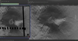
    a few years back i reprocesed the real venus data from Megelian mission
    -- removed the striping and extracted shading related height data

    this did take 6 to 7 months of near full time work

    and when it is 0 F to -15 F outside ....


    the orig on the left and the cleaned up on the right ( one small area anyway )


    so plan on the TIME NEEDED
    and the amount of time you CAN devote to it
    ( with some TIME OFF TO DO SOMETHING COMPLETELY DIFFERENT FOR A DAY OR THREE !!! )
    --- 90 seconds to Midnight ---
    --------

    --- Penguin power!!! ---


  9. #19

    Default

    I have a lot of time anyway currently, and probably will for awhile, so thats not much of an issue...

    But, wow...You can't really tell it's not real data...Wow.

Page 2 of 2 FirstFirst 12

Posting Permissions

  • You may not post new threads
  • You may not post replies
  • You may not post attachments
  • You may not edit your posts
  •