Results 1 to 7 of 7

Thread: The Chronicles of Hera

  1. #1

    Wip The Chronicles of Hera


    The Chronicles of Hera is the universe on which I have been working for a very long time. Its creation is actually the incidence of having lots of ideas and stories of adventures. These stories had to have context and it couldn't took place in our history or our world, or even in each of their respective world, as they deal with fantastic materials like dragons, werewolves, magic and elves and that I can't bring myself to have too many worlds. So I started to work on A world, a continent, and one thing leading to another it became the map that you will see below.

    I currently have 3 story concepts unfolding in this world, however this world is not strictly for my stories. I always wanted to make it a roleplay tool. This is also why I continue to work on the universe so that one day I can roleplay in it with my friends.

    All that being said, it's a huge WIP, although I've been working on it for over 10 years. There are still a lot of names that are just placeholders for now. Everything is still subject to changes actually.

    I pusblish this here today in the hope that I can be helped and assisted in working on my world. As you could see in my presentation, my world had quite the evolution. And I am looking forward to keep improving it with your tips.

    The pictures below are not processed, they are as they appear in the software Wonderdraft. For a "finished" or at least what it should look like when I'm finished, you can look here (but this one is not up to date yet) : https://www.easyzoom.com/image/278296


    Last edited by Kâ Lys; 10-14-2021 at 09:10 PM.

  2. #2
    Software Dev/Rep Hai-Etlik's Avatar
    Join Date
    May 2009
    Location
    48° 28′ N 123° 8′ W
    Posts
    1,333
    Blog Entries
    1

    Default

    So, something to be aware of is that all those things like compass roses and grids and the chequed border that you often see on maps are functional parts of the map that say things about it, and it's possibly for them to say contradictory or nonsensical things.

    Looking at the landforms, it seems like this is probably meant to be a Mercator projection, but the square grid (graticule) and even spacing of the chequed border suggest it's a cylindrical equidistant projection. However the aspect ratio is wrong for that and the chequed border doesn't line up with the graticule. You also have a compass rose suggesting the map is bearing preserving which would be appropriate for a Mercator map but not a cylindrical equidistant one.

    There's also a bit of a missmatched quality to the map. It is broadly designed as a fairly modern looking reference map but then you have some bits trying to look archaic like the texture and mountain symbols, and then other elements like the way graticule and text halos are drawn as precise light lines over the background texture which are aggressively obvious as being done with a computer. It makes it feel like it doesn't know what it's trying to be.

    One other thing is that you have roughly circular continents centred on each pole. That's not impossible but it does look rather suspicious. Earth currently has one somewhat less circular continent somewhat less centred on one pole. That's just happenstance though. The chance that a planet would have two at once is really low, and yet fantasy map makers do it all the time so it really draws attention to itself as looking fake. There are ice caps, but they are variable, if you look at maps that show them you'll see they are represented differently from coastlines, usually smooth and simplified and often with a dashed line to indicate that they are generalized from a varying shape.

  3. #3
    Guild Member Facebook Connected Ryan Pourchot's Avatar
    Join Date
    Aug 2017
    Location
    Texas, USA
    Posts
    88

    Default

    Impressive layout. I too have been working on my universe for close to a decade. A lot of work indeed.
    Did you create the world from a tectonic basis? The continental crust implies that you have.
    And ocean currents or weather patterns?
    Looking forward to seeing more.

    Sent from my SM-G988U using Tapatalk

  4. #4
    Guild Journeyer Peter Toth's Avatar
    Join Date
    Jan 2018
    Location
    Port Development, British Columbia, Canada
    Posts
    224

    Default

    Hi Ka Lys,

    That's some very exquisite work you've done there, and I can understand why it's taken over ten years to get this far. Those continent shapes look very realistic, realism being a very important element in my own cartography. Is this planet like the Earth in its dimensions, or is it somewhat different? Have you developed any other physical details? I'm sure the lore will be the most important aspect in this map, and I eagerly look forward to viewing it. Thanks for submitting!

    Peter

  5. #5
    Guild Novice
    Join Date
    May 2021
    Location
    Chicago, IL
    Posts
    11

    Post Wow

    This is amazing. I am very new in the map making space, but ultimately am hoping to make something on this scale. This has definitely inspired and motivated me further. Thank you for sharing.

  6. #6

    Default

    Quote Originally Posted by Hai-Etlik View Post
    So, something to be aware of is that all those things like compass roses and grids and the chequed border that you often see on maps are functional parts of the map that say things about it, and it's possibly for them to say contradictory or nonsensical things.

    Looking at the landforms, it seems like this is probably meant to be a Mercator projection, but the square grid (graticule) and even spacing of the chequed border suggest it's a cylindrical equidistant projection. However the aspect ratio is wrong for that and the chequed border doesn't line up with the graticule. You also have a compass rose suggesting the map is bearing preserving which would be appropriate for a Mercator map but not a cylindrical equidistant one.

    There's also a bit of a missmatched quality to the map. It is broadly designed as a fairly modern looking reference map but then you have some bits trying to look archaic like the texture and mountain symbols, and then other elements like the way graticule and text halos are drawn as precise light lines over the background texture which are aggressively obvious as being done with a computer. It makes it feel like it doesn't know what it's trying to be.

    One other thing is that you have roughly circular continents centred on each pole. That's not impossible but it does look rather suspicious. Earth currently has one somewhat less circular continent somewhat less centred on one pole. That's just happenstance though. The chance that a planet would have two at once is really low, and yet fantasy map makers do it all the time so it really draws attention to itself as looking fake. There are ice caps, but they are variable, if you look at maps that show them you'll see they are represented differently from coastlines, usually smooth and simplified and often with a dashed line to indicate that they are generalized from a varying shape.
    Hi Hai-Etlik and thanks for this great answer! And while I appreciate your advise, I don't believe them to be appropriate for me or my map, and by that I just mean that I never intended for my map to be a work of geography per se. Like Middle-Earth, Warhammer, Hyboria, Westeros, I'm fine with it not strictly following a scientific process or logic. That being said, I don't think I need the compass since it is quite obvious where the north is and I don't want to misuse unecessary real tools that could confuse people into wondering if the map is supposed to be scientificaly accurate or not. As for the grid it is more a visual tool to help estimate the distance between places, so it doesn't have the same use as the the Earth longitude/lattitude grid, I think anyway. I'll probably remove it at some point and be content with only a scale in the legend table at the bottom of the map.

    Also concerning the after effects used for my map, I don't think I will use it again. That was just me exploring things I could do with the softwares. In any case, if I use it again, I will also publish a version that is clean and let people decide what they like more. And regarding the poles, I already removed the north pole entirely as you can see in the map above (silhouette map).

    Anyway thank you very much for your tips and for your time, I appreciate it!


    Quote Originally Posted by Ryan Pourchot View Post
    Impressive layout. I too have been working on my universe for close to a decade. A lot of work indeed.
    Did you create the world from a tectonic basis? The continental crust implies that you have.
    And ocean currents or weather patterns?
    Looking forward to seeing more.

    Sent from my SM-G988U using Tapatalk
    Thank you! And nope, never used the tectonic method, but I get that comment a lot actually and I appreciate that. Must mean I do something right. 
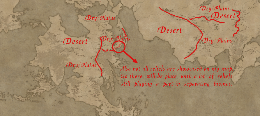
I also don't work on ocean currents or weather patterns (so far anyway). I just have few set of rules that I try to follow as stricly as I can and here they are :

    1. Continents have irregular shapes and islands along their coast, and they complete each other like a puzzle.
    2. Moutains are nor totally straight nor totally zigzagging, or worst, perpendicular to each other. And I guess just like going through the entire process of creating a tectonic schema, I visualise another puzzle layer for my mountains and add them according to that puzzle. So when I've finish adding the mountains, I can see the division of land/or tectonic plates with a glance.
    3. Rivers comes down from mountains or lake that are themselves creates from water coming from mountains, rivers always joins, rarely splits and when they do, 99% of the time they are delta's. Never have more than 4 delta's showing on your world map or 1 delta on your regional map.
    4. Forest often grows abundantly around fresh waters, being rivers or lakes, and are usually more on terrain that have a significative fluctuating reliefs (which allow for fresh/rain waters to always move and not stay static) than on plains where waters just sink in the ground where it falls and does not favorise the growth of forest (usually anyway).
    5. There's often two side of a mountains, one that is dry and another that is moist. That has to do with winds and without having to figure it all out, I try to balance this the best I can. Desert tend to be created where rains/moisted wind do not go, so let's say between two moutains ranges like you can find in China, or sometimes the land is so far away from water, plus being blocked by a lot of mountains, that you get something like North Africa. But you will also find place that even though have a mountain range, they have abundant forest on both side and surrounding this mountain range like the Alps.


    Now my method isn't at all scientific, but it allows to simulate something that looks realistic and credible to most people, unless you are an expert which 99.99% of people are not.


    Quote Originally Posted by Peter Toth View Post
    Hi Ka Lys,

    That's some very exquisite work you've done there, and I can understand why it's taken over ten years to get this far. Those continent shapes look very realistic, realism being a very important element in my own cartography. Is this planet like the Earth in its dimensions, or is it somewhat different? Have you developed any other physical details? I'm sure the lore will be the most important aspect in this map, and I eagerly look forward to viewing it. Thanks for submitting!

    Peter
    Thank you Peter! Yes, Hera is loosely based on Earth and its history. Like the examples above, which are Warhammer, Westeros, Hyboria and so on, I anchor the principles of my world in ours. To make it short though, not to bore anyone anymore than I already have, these are very appealing worlds to me because my brain doesn't absord or like things that are too alien (like Middle Earth is on many level I'd say, hence why it is not my favorite fantasy). That's basically it. But there's also the fact that these worlds, because they are so grounded in our own world's history, myths or just overall essence, gave me the love of History. Without these worlds and their familiar lore, I don't think I would have ever took time to read about history, real epic events, real political schemes that would hook me like I am today. Now I often get criticise for working on a world that looks too much like Earth, but usually these critics come from veteran worldbuilders that have a strong knowledge about real world history. To them it looks cheap for some reason. But to me, I see it from the perspective of the ignorant boy I was about history. Most people don't have knowledge of history like us veteran worldbuilders, so to those that do not know, it is a discovery and relatable content that they can look up and eventually get hook on historical anecdotes. And yes even regarding the dimension of Hera, it is very much like earth. A 128 pixels on the original map size equal 500 km. For the lore I'll post about it later on, about the origin of men in the Meneland area.

  7. #7

    Default

    Quote Originally Posted by Tater View Post
    This is amazing. I am very new in the map making space, but ultimately am hoping to make something on this scale. This has definitely inspired and motivated me further. Thank you for sharing.
    Thank you very much and glad I could help with your motivation!

Posting Permissions

  • You may not post new threads
  • You may not post replies
  • You may not post attachments
  • You may not edit your posts
  •